You are here: Home > Network List > TA - USArray Transportable Network (new EarthScope stations) Stations List
> Station D25K Kavik River, AK, USA > Earthquake Result Viewer
D25K Kavik River, AK, USA - Earthquake Result Viewer
| Earthquake location: |
Solomon Islands |
| Earthquake latitude/longitude: |
-6.5/154.3 |
| Earthquake time(UTC): |
2020/04/25 (116) 02:53:05 GMT |
| Earthquake Depth: |
17 km |
| Earthquake Magnitude: |
6.3 mww |
| Earthquake Catalog/Contributor: |
NEIC PDE/us |
|
| Network: |
TA USArray Transportable Network (new EarthScope stations) |
| Station: |
D25K Kavik River, AK, USA |
| Lat/Lon: |
69.32 N/146.38 W |
| Elevation: |
770 m |
|
| Distance: |
85.7 deg |
| Az: |
17.839 deg |
| Baz: |
238.981 deg |
| Ray Param: |
0.044557042 |
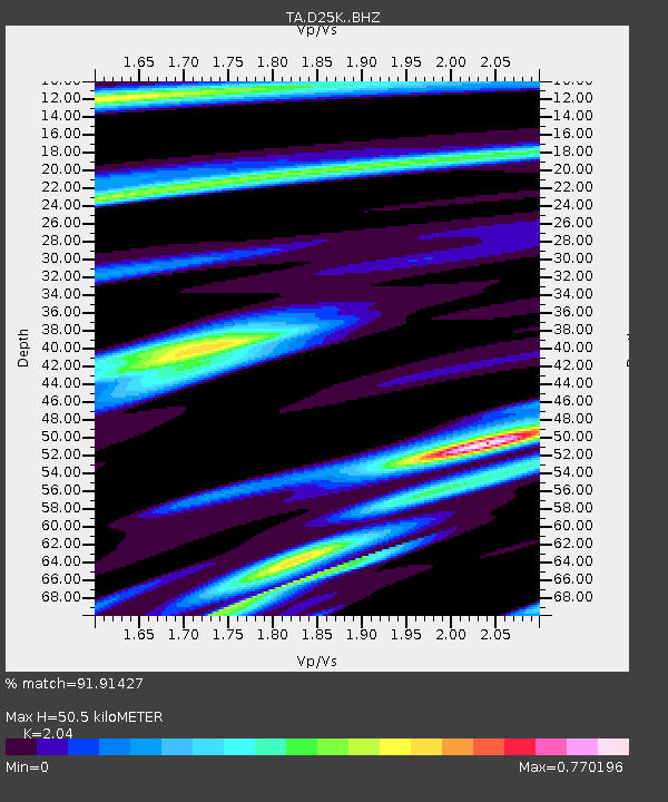
| Estimated Moho Depth: |
50.5 km |
| Estimated Crust Vp/Vs: |
2.04 |
| Assumed Crust Vp: |
6.378 km/s |
| Estimated Crust Vs: |
3.127 km/s |
| Estimated Crust Poisson's Ratio: |
0.34 |
|
| Radial Match: |
91.91427 % |
| Radial Bump: |
400 |
| Transverse Match: |
70.380196 % |
| Transverse Bump: |
400 |
| SOD ConfigId: |
21166931 |
| Insert Time: |
2020-05-09 03:02:49.579 +0000 |
| GWidth: |
2.5 |
| Max Bumps: |
400 |
| Tol: |
0.001 |
|
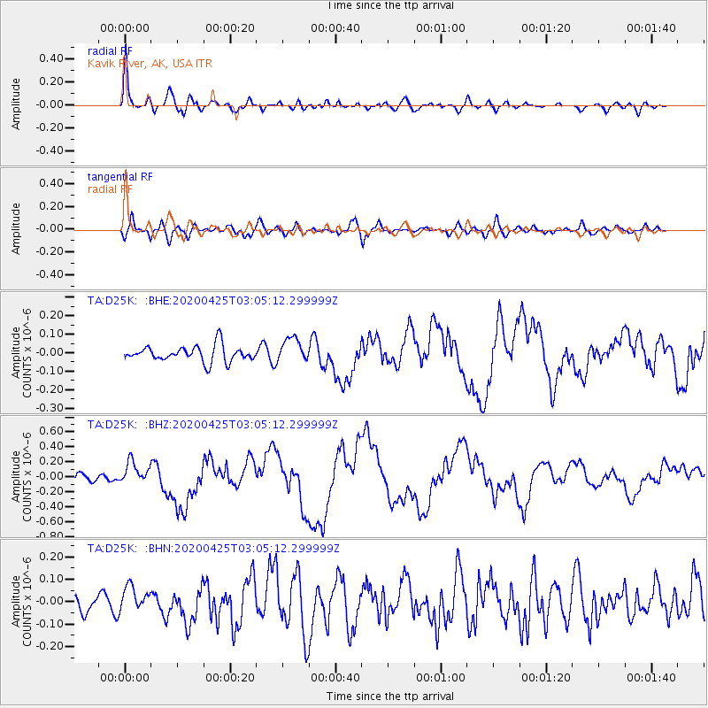
Signal To Noise
| Channel | StoN | STA | LTA |
| TA:D25K: :BHZ:20200425T03:05:12.299999Z | 3.1652184 | 1.5477444E-7 | 4.8898507E-8 |
| TA:D25K: :BHN:20200425T03:05:12.299999Z | 1.262647 | 5.4813125E-8 | 4.341128E-8 |
| TA:D25K: :BHE:20200425T03:05:12.299999Z | 1.5217073 | 6.510966E-8 | 4.2787242E-8 |
| Arrivals |
| Ps | 8.4 SECOND |
| PpPs | 24 SECOND |
| PsPs/PpSs | 32 SECOND |


