You are here: Home > Network List > TA - USArray Transportable Network (new EarthScope stations) Stations List
> Station E18K Tukpahlearik Creek, AK, USA > Earthquake Result Viewer
E18K Tukpahlearik Creek, AK, USA - Earthquake Result Viewer
| Earthquake location: |
Solomon Islands |
| Earthquake latitude/longitude: |
-6.5/154.3 |
| Earthquake time(UTC): |
2020/04/25 (116) 02:53:05 GMT |
| Earthquake Depth: |
17 km |
| Earthquake Magnitude: |
6.3 mww |
| Earthquake Catalog/Contributor: |
NEIC PDE/us |
|
| Network: |
TA USArray Transportable Network (new EarthScope stations) |
| Station: |
E18K Tukpahlearik Creek, AK, USA |
| Lat/Lon: |
67.42 N/160.60 W |
| Elevation: |
297 m |
|
| Distance: |
80.4 deg |
| Az: |
16.105 deg |
| Baz: |
225.546 deg |
| Ray Param: |
0.04830058 |
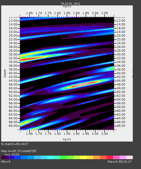
| Estimated Moho Depth: |
45.75 km |
| Estimated Crust Vp/Vs: |
1.93 |
| Assumed Crust Vp: |
6.276 km/s |
| Estimated Crust Vs: |
3.248 km/s |
| Estimated Crust Poisson's Ratio: |
0.32 |
|
| Radial Match: |
90.4037 % |
| Radial Bump: |
400 |
| Transverse Match: |
65.52247 % |
| Transverse Bump: |
400 |
| SOD ConfigId: |
21166931 |
| Insert Time: |
2020-05-09 03:02:55.099 +0000 |
| GWidth: |
2.5 |
| Max Bumps: |
400 |
| Tol: |
0.001 |
|
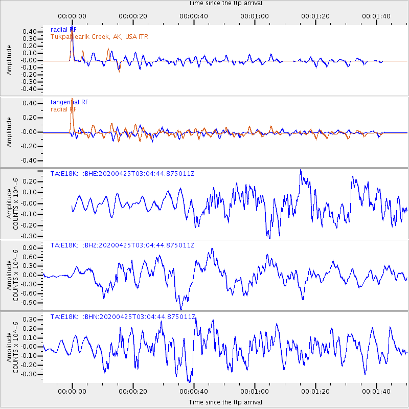
Signal To Noise
| Channel | StoN | STA | LTA |
| TA:E18K: :BHZ:20200425T03:04:44.875011Z | 2.4904878 | 1.5954572E-7 | 6.406204E-8 |
| TA:E18K: :BHN:20200425T03:04:44.875011Z | 2.4726486 | 8.516579E-8 | 3.444314E-8 |
| TA:E18K: :BHE:20200425T03:04:44.875011Z | 1.3338803 | 6.317707E-8 | 4.7363372E-8 |
| Arrivals |
| Ps | 7.0 SECOND |
| PpPs | 21 SECOND |
| PsPs/PpSs | 28 SECOND |


