You are here: Home > Network List > TA - USArray Transportable Network (new EarthScope stations) Stations List
> Station E20K Nigu River, AK, USA > Earthquake Result Viewer
E20K Nigu River, AK, USA - Earthquake Result Viewer
| Earthquake location: |
Solomon Islands |
| Earthquake latitude/longitude: |
-6.5/154.3 |
| Earthquake time(UTC): |
2020/04/25 (116) 02:53:05 GMT |
| Earthquake Depth: |
17 km |
| Earthquake Magnitude: |
6.3 mww |
| Earthquake Catalog/Contributor: |
NEIC PDE/us |
|
| Network: |
TA USArray Transportable Network (new EarthScope stations) |
| Station: |
E20K Nigu River, AK, USA |
| Lat/Lon: |
68.26 N/156.19 W |
| Elevation: |
866 m |
|
| Distance: |
82.2 deg |
| Az: |
16.619 deg |
| Baz: |
229.708 deg |
| Ray Param: |
0.04704968 |
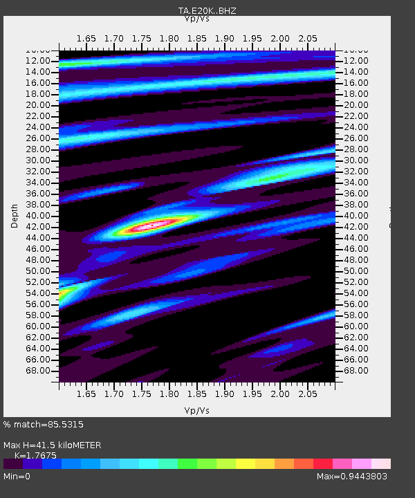
| Estimated Moho Depth: |
41.5 km |
| Estimated Crust Vp/Vs: |
1.77 |
| Assumed Crust Vp: |
6.221 km/s |
| Estimated Crust Vs: |
3.52 km/s |
| Estimated Crust Poisson's Ratio: |
0.26 |
|
| Radial Match: |
85.5315 % |
| Radial Bump: |
400 |
| Transverse Match: |
66.61453 % |
| Transverse Bump: |
400 |
| SOD ConfigId: |
21166931 |
| Insert Time: |
2020-05-09 03:02:57.816 +0000 |
| GWidth: |
2.5 |
| Max Bumps: |
400 |
| Tol: |
0.001 |
|
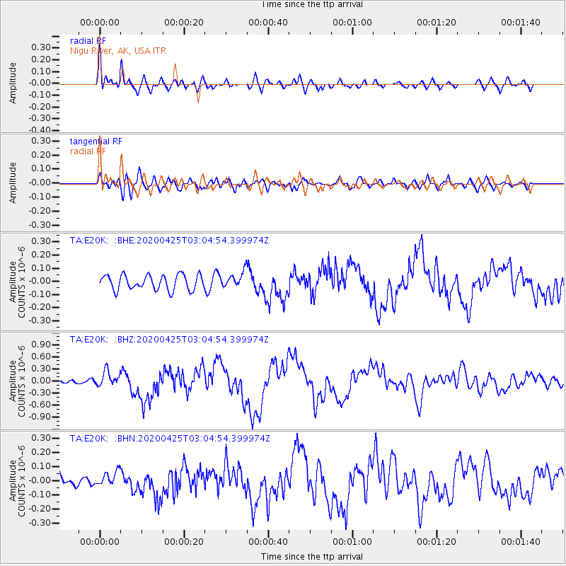
Signal To Noise
| Channel | StoN | STA | LTA |
| TA:E20K: :BHZ:20200425T03:04:54.399974Z | 3.8566575 | 1.9638304E-7 | 5.092053E-8 |
| TA:E20K: :BHN:20200425T03:04:54.399974Z | 0.8179591 | 5.4938578E-8 | 6.716544E-8 |
| TA:E20K: :BHE:20200425T03:04:54.399974Z | 1.0572475 | 5.937199E-8 | 5.6157134E-8 |
| Arrivals |
| Ps | 5.2 SECOND |
| PpPs | 18 SECOND |
| PsPs/PpSs | 23 SECOND |


