You are here: Home > Network List > TA - USArray Transportable Network (new EarthScope stations) Stations List
> Station F21K Alatna River, AK, USA > Earthquake Result Viewer
F21K Alatna River, AK, USA - Earthquake Result Viewer
| Earthquake location: |
Solomon Islands |
| Earthquake latitude/longitude: |
-6.5/154.3 |
| Earthquake time(UTC): |
2020/04/25 (116) 02:53:05 GMT |
| Earthquake Depth: |
17 km |
| Earthquake Magnitude: |
6.3 mww |
| Earthquake Catalog/Contributor: |
NEIC PDE/us |
|
| Network: |
TA USArray Transportable Network (new EarthScope stations) |
| Station: |
F21K Alatna River, AK, USA |
| Lat/Lon: |
67.22 N/153.48 W |
| Elevation: |
597 m |
|
| Distance: |
82.3 deg |
| Az: |
18.09 deg |
| Baz: |
232.408 deg |
| Ray Param: |
0.04694611 |
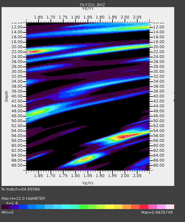
| Estimated Moho Depth: |
22.0 km |
| Estimated Crust Vp/Vs: |
1.60 |
| Assumed Crust Vp: |
6.455 km/s |
| Estimated Crust Vs: |
4.035 km/s |
| Estimated Crust Poisson's Ratio: |
0.18 |
|
| Radial Match: |
84.95596 % |
| Radial Bump: |
400 |
| Transverse Match: |
67.0377 % |
| Transverse Bump: |
400 |
| SOD ConfigId: |
21166931 |
| Insert Time: |
2020-05-09 03:03:16.320 +0000 |
| GWidth: |
2.5 |
| Max Bumps: |
400 |
| Tol: |
0.001 |
|

Signal To Noise
| Channel | StoN | STA | LTA |
| TA:F21K: :BHZ:20200425T03:04:55.174999Z | 2.5704796 | 1.6457972E-7 | 6.402686E-8 |
| TA:F21K: :BHN:20200425T03:04:55.174999Z | 1.070865 | 5.5258152E-8 | 5.1601415E-8 |
| TA:F21K: :BHE:20200425T03:04:55.174999Z | 1.4046224 | 5.0309662E-8 | 3.5817212E-8 |
| Arrivals |
| Ps | 2.1 SECOND |
| PpPs | 8.6 SECOND |
| PsPs/PpSs | 11 SECOND |


