You are here: Home > Network List > TA - USArray Transportable Network (new EarthScope stations) Stations List
> Station F24K Squaw Lake, AK, USA > Earthquake Result Viewer
F24K Squaw Lake, AK, USA - Earthquake Result Viewer
| Earthquake location: |
Solomon Islands |
| Earthquake latitude/longitude: |
-6.5/154.3 |
| Earthquake time(UTC): |
2020/04/25 (116) 02:53:05 GMT |
| Earthquake Depth: |
17 km |
| Earthquake Magnitude: |
6.3 mww |
| Earthquake Catalog/Contributor: |
NEIC PDE/us |
|
| Network: |
TA USArray Transportable Network (new EarthScope stations) |
| Station: |
F24K Squaw Lake, AK, USA |
| Lat/Lon: |
67.52 N/147.89 W |
| Elevation: |
736 m |
|
| Distance: |
84.3 deg |
| Az: |
19.093 deg |
| Baz: |
237.685 deg |
| Ray Param: |
0.0455809 |
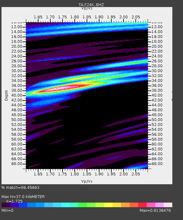
| Estimated Moho Depth: |
37.0 km |
| Estimated Crust Vp/Vs: |
1.73 |
| Assumed Crust Vp: |
6.522 km/s |
| Estimated Crust Vs: |
3.781 km/s |
| Estimated Crust Poisson's Ratio: |
0.25 |
|
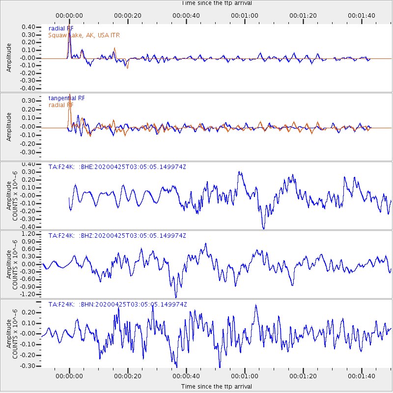
| Radial Match: |
86.45663 % |
| Radial Bump: |
400 |
| Transverse Match: |
61.023796 % |
| Transverse Bump: |
400 |
| SOD ConfigId: |
21166931 |
| Insert Time: |
2020-05-09 03:03:18.877 +0000 |
| GWidth: |
2.5 |
| Max Bumps: |
400 |
| Tol: |
0.001 |
|
Signal To Noise
| Channel | StoN | STA | LTA |
| TA:F24K: :BHZ:20200425T03:05:05.149974Z | 2.5109274 | 1.7178527E-7 | 6.841507E-8 |
| TA:F24K: :BHN:20200425T03:05:05.149974Z | 1.1946751 | 6.1056E-8 | 5.1106785E-8 |
| TA:F24K: :BHE:20200425T03:05:05.149974Z | 1.0291061 | 7.6931165E-8 | 7.4755334E-8 |
| Arrivals |
| Ps | 4.2 SECOND |
| PpPs | 15 SECOND |
| PsPs/PpSs | 19 SECOND |


