You are here: Home > Network List > TA - USArray Transportable Network (new EarthScope stations) Stations List
> Station N17K Nushagak Hills, AK, USA > Earthquake Result Viewer
N17K Nushagak Hills, AK, USA - Earthquake Result Viewer
| Earthquake location: |
Solomon Islands |
| Earthquake latitude/longitude: |
-6.5/154.3 |
| Earthquake time(UTC): |
2020/04/25 (116) 02:53:05 GMT |
| Earthquake Depth: |
17 km |
| Earthquake Magnitude: |
6.3 mww |
| Earthquake Catalog/Contributor: |
NEIC PDE/us |
|
| Network: |
TA USArray Transportable Network (new EarthScope stations) |
| Station: |
N17K Nushagak Hills, AK, USA |
| Lat/Lon: |
60.53 N/157.19 W |
| Elevation: |
350 m |
|
| Distance: |
76.8 deg |
| Az: |
22.36 deg |
| Baz: |
229.853 deg |
| Ray Param: |
0.050711993 |
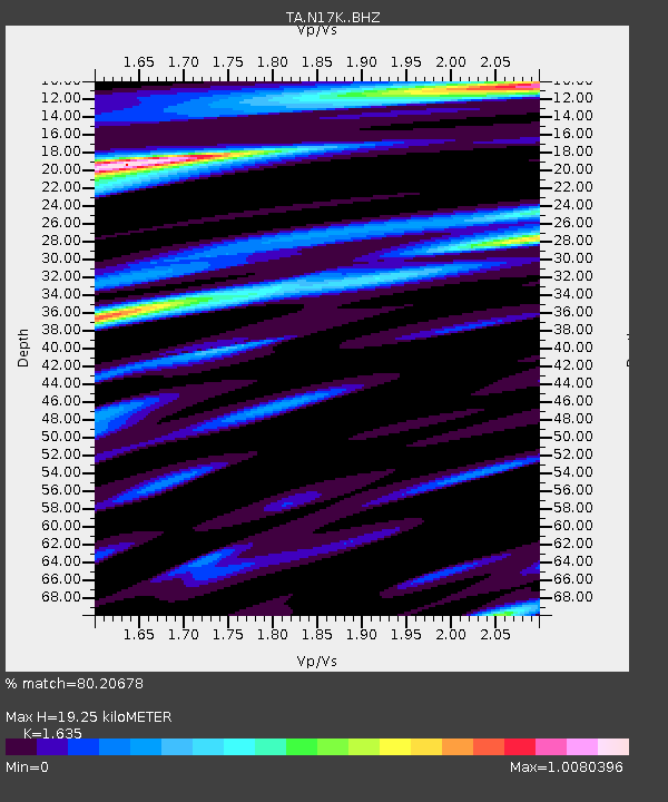
| Estimated Moho Depth: |
19.25 km |
| Estimated Crust Vp/Vs: |
1.63 |
| Assumed Crust Vp: |
6.155 km/s |
| Estimated Crust Vs: |
3.764 km/s |
| Estimated Crust Poisson's Ratio: |
0.20 |
|
| Radial Match: |
80.20678 % |
| Radial Bump: |
400 |
| Transverse Match: |
62.506435 % |
| Transverse Bump: |
400 |
| SOD ConfigId: |
21166931 |
| Insert Time: |
2020-05-09 03:04:05.706 +0000 |
| GWidth: |
2.5 |
| Max Bumps: |
400 |
| Tol: |
0.001 |
|

Signal To Noise
| Channel | StoN | STA | LTA |
| TA:N17K: :BHZ:20200425T03:04:25.399974Z | 1.9253784 | 4.0754475E-7 | 2.1166994E-7 |
| TA:N17K: :BHN:20200425T03:04:25.399974Z | 0.7468319 | 1.4973516E-7 | 2.0049377E-7 |
| TA:N17K: :BHE:20200425T03:04:25.399974Z | 0.3967261 | 6.738606E-8 | 1.6985537E-7 |
| Arrivals |
| Ps | 2.0 SECOND |
| PpPs | 8.0 SECOND |
| PsPs/PpSs | 10 SECOND |


