You are here: Home > Network List > NE - New England Seismic Network Stations List
> Station EMMW Machias, ME, USA > Earthquake Result Viewer
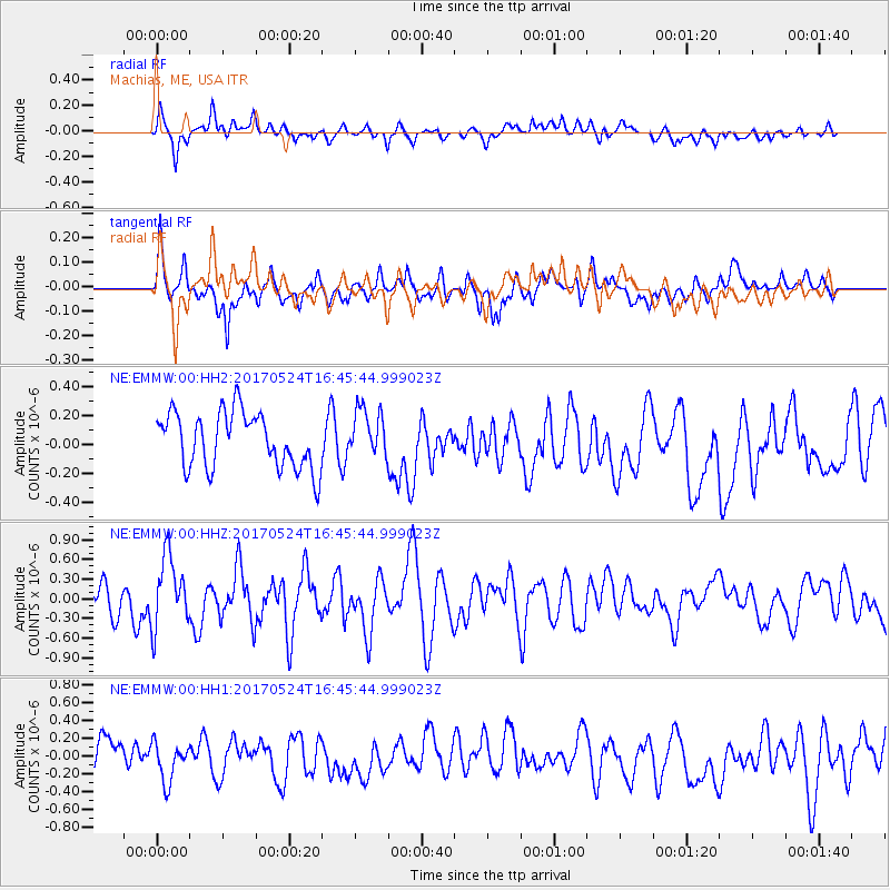
EMMW Machias, ME, USA - Earthquake Result Viewer
*The percent match for this event was below the threshold and hence no stack was calculated.
| Earthquake location: |
Fox Islands, Aleutian Islands |
| Earthquake latitude/longitude: |
52.4/-166.7 |
| Earthquake time(UTC): |
2017/05/24 (144) 16:36:01 GMT |
| Earthquake Depth: |
2.0 km |
| Earthquake Magnitude: |
5.7 Mi |
| Earthquake Catalog/Contributor: |
NEIC PDE/at |
|
| Network: |
NE New England Seismic Network |
| Station: |
EMMW Machias, ME, USA |
| Lat/Lon: |
44.71 N/67.46 W |
| Elevation: |
35 m |
|
| Distance: |
61.1 deg |
| Az: |
53.541 deg |
| Baz: |
316.306 deg |
| Ray Param: |
$rayparam |
*The percent match for this event was below the threshold and hence was not used in the summary stack. |
|
| Radial Match: |
69.00855 % |
| Radial Bump: |
400 |
| Transverse Match: |
65.45253 % |
| Transverse Bump: |
400 |
| SOD ConfigId: |
2028011 |
| Insert Time: |
2017-06-07 16:41:45.991 +0000 |
| GWidth: |
2.5 |
| Max Bumps: |
400 |
| Tol: |
0.001 |
|
Signal To Noise
| Channel | StoN | STA | LTA |
| NE:EMMW:00:HHZ:20170524T16:45:44.999023Z | 1.8560839 | 5.301916E-7 | 2.8565066E-7 |
| NE:EMMW:00:HH1:20170524T16:45:44.999023Z | 1.2929461 | 2.1646284E-7 | 1.674183E-7 |
| NE:EMMW:00:HH2:20170524T16:45:44.999023Z | 0.8598595 | 1.6451061E-7 | 1.9132266E-7 |
| Arrivals |
| Ps | |
| PpPs | |
| PsPs/PpSs | |


