You are here: Home > Network List > TS - TERRAscope (Southern California Seismic Network) Stations List
> Station SBC Santa Barbara, California, USA > Earthquake Result Viewer
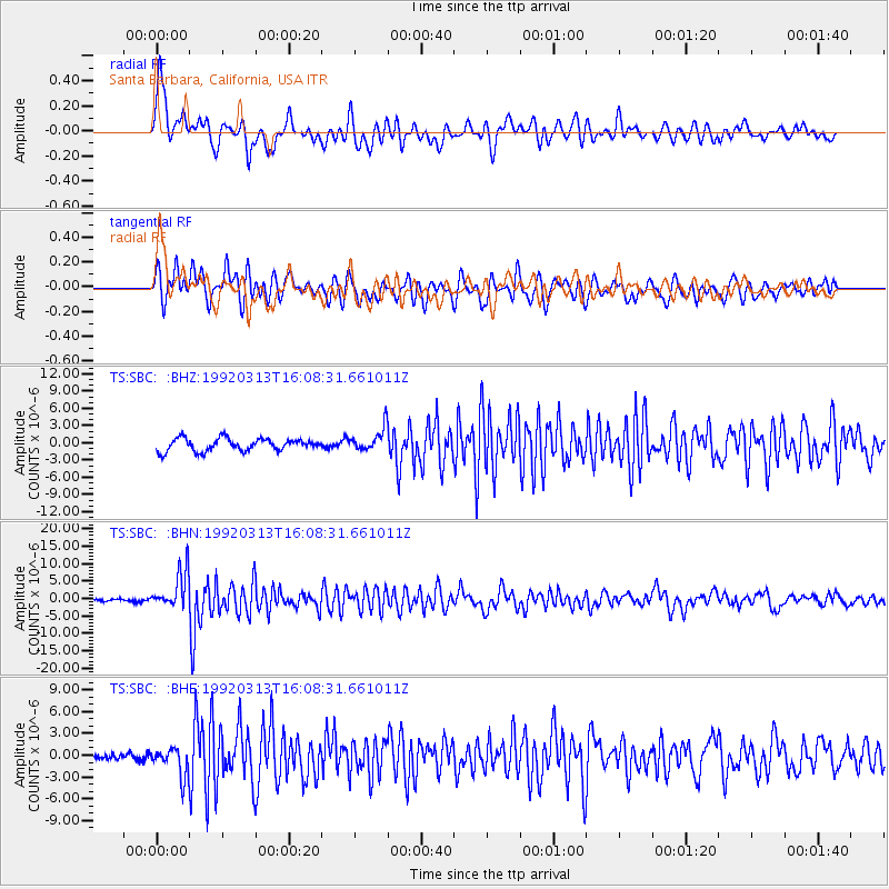
SBC Santa Barbara, California, USA - Earthquake Result Viewer
*The percent match for this event was below the threshold and hence no stack was calculated.
| Earthquake location: |
Andreanof Islands, Aleutian Is. |
| Earthquake latitude/longitude: |
52.5/-178.9 |
| Earthquake time(UTC): |
1992/03/13 (073) 16:01:06 GMT |
| Earthquake Depth: |
211 km |
| Earthquake Magnitude: |
6.0 MB, 6.3 UNKNOWN |
| Earthquake Catalog/Contributor: |
WHDF/NEIC |
|
| Network: |
TS TERRAscope (Southern California Seismic Network) |
| Station: |
SBC Santa Barbara, California, USA |
| Lat/Lon: |
34.44 N/119.71 W |
| Elevation: |
90 m |
|
| Distance: |
45.2 deg |
| Az: |
89.217 deg |
| Baz: |
312.271 deg |
| Ray Param: |
$rayparam |
*The percent match for this event was below the threshold and hence was not used in the summary stack. |
|
| Radial Match: |
75.031364 % |
| Radial Bump: |
400 |
| Transverse Match: |
70.58233 % |
| Transverse Bump: |
400 |
| SOD ConfigId: |
4480 |
| Insert Time: |
2010-02-26 14:48:49.447 +0000 |
| GWidth: |
2.5 |
| Max Bumps: |
400 |
| Tol: |
0.001 |
|
Signal To Noise
| Channel | StoN | STA | LTA |
| TS:SBC: :BHN:19920313T16:08:31.661011Z | 14.413338 | 5.3819026E-6 | 3.7339737E-7 |
| TS:SBC: :BHE:19920313T16:08:31.661011Z | 4.5278378 | 1.9468678E-6 | 4.2997738E-7 |
| TS:SBC: :BHZ:19920313T16:08:31.661011Z | 1.8431449 | 2.0076147E-6 | 1.0892334E-6 |
| Arrivals |
| Ps | |
| PpPs | |
| PsPs/PpSs | |


