You are here: Home > Network List > US - United States National Seismic Network Stations List
> Station AMTX Amarillo, Texas, USA > Earthquake Result Viewer
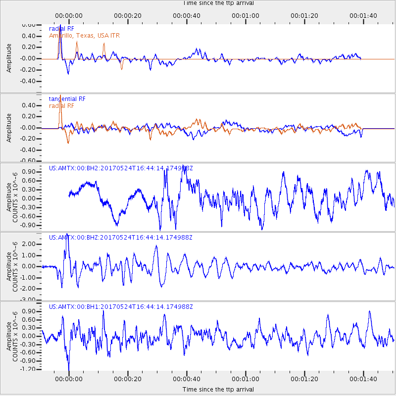
AMTX Amarillo, Texas, USA - Earthquake Result Viewer
*The percent match for this event was below the threshold and hence no stack was calculated.
| Earthquake location: |
Fox Islands, Aleutian Islands |
| Earthquake latitude/longitude: |
52.4/-166.7 |
| Earthquake time(UTC): |
2017/05/24 (144) 16:36:01 GMT |
| Earthquake Depth: |
2.0 km |
| Earthquake Magnitude: |
5.7 Mi |
| Earthquake Catalog/Contributor: |
NEIC PDE/at |
|
| Network: |
US United States National Seismic Network |
| Station: |
AMTX Amarillo, Texas, USA |
| Lat/Lon: |
34.53 N/101.41 W |
| Elevation: |
1010 m |
|
| Distance: |
48.9 deg |
| Az: |
84.453 deg |
| Baz: |
312.408 deg |
| Ray Param: |
$rayparam |
*The percent match for this event was below the threshold and hence was not used in the summary stack. |
|
| Radial Match: |
68.83195 % |
| Radial Bump: |
400 |
| Transverse Match: |
37.609795 % |
| Transverse Bump: |
400 |
| SOD ConfigId: |
2028011 |
| Insert Time: |
2017-06-07 16:42:57.578 +0000 |
| GWidth: |
2.5 |
| Max Bumps: |
400 |
| Tol: |
0.001 |
|
Signal To Noise
| Channel | StoN | STA | LTA |
| US:AMTX:00:BHZ:20170524T16:44:14.174988Z | 12.0941105 | 1.3104248E-6 | 1.0835231E-7 |
| US:AMTX:00:BH1:20170524T16:44:14.174988Z | 2.8837469 | 4.7428972E-7 | 1.6446995E-7 |
| US:AMTX:00:BH2:20170524T16:44:14.174988Z | 1.3013306 | 5.1103257E-7 | 3.9270003E-7 |
| Arrivals |
| Ps | |
| PpPs | |
| PsPs/PpSs | |


