You are here: Home > Network List > US - United States National Seismic Network Stations List
> Station MSO Missoula, Montana, USA > Earthquake Result Viewer
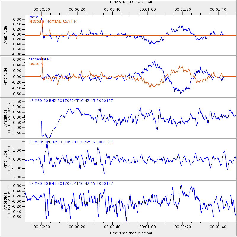
MSO Missoula, Montana, USA - Earthquake Result Viewer
*The percent match for this event was below the threshold and hence no stack was calculated.
| Earthquake location: |
Fox Islands, Aleutian Islands |
| Earthquake latitude/longitude: |
52.4/-166.7 |
| Earthquake time(UTC): |
2017/05/24 (144) 16:36:01 GMT |
| Earthquake Depth: |
2.0 km |
| Earthquake Magnitude: |
5.7 Mi |
| Earthquake Catalog/Contributor: |
NEIC PDE/at |
|
| Network: |
US United States National Seismic Network |
| Station: |
MSO Missoula, Montana, USA |
| Lat/Lon: |
46.83 N/113.94 W |
| Elevation: |
1264 m |
|
| Distance: |
34.0 deg |
| Az: |
77.934 deg |
| Baz: |
299.275 deg |
| Ray Param: |
$rayparam |
*The percent match for this event was below the threshold and hence was not used in the summary stack. |
|
| Radial Match: |
53.666466 % |
| Radial Bump: |
400 |
| Transverse Match: |
34.040894 % |
| Transverse Bump: |
400 |
| SOD ConfigId: |
2028011 |
| Insert Time: |
2017-06-07 16:43:57.373 +0000 |
| GWidth: |
2.5 |
| Max Bumps: |
400 |
| Tol: |
0.001 |
|
Signal To Noise
| Channel | StoN | STA | LTA |
| US:MSO:00:BHZ:20170524T16:42:15.200012Z | 9.107957 | 1.017051E-6 | 1.116662E-7 |
| US:MSO:00:BH1:20170524T16:42:15.200012Z | 0.75980693 | 3.6295182E-7 | 4.776895E-7 |
| US:MSO:00:BH2:20170524T16:42:15.200012Z | 0.61725223 | 6.0427334E-7 | 9.789732E-7 |
| Arrivals |
| Ps | |
| PpPs | |
| PsPs/PpSs | |


