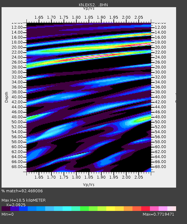
EKS2 KN.EKS2 - Earthquake Result Viewer
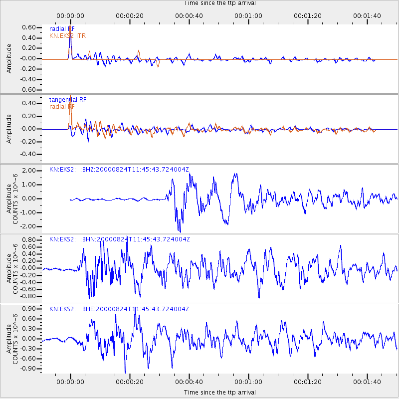
Earthquake location: Southwest Of Sumatra, Indonesia
Earthquake latitude/longitude: -6.0/102.7
Earthquake time(UTC): 2000/08/24 (237) 11:36:45 GMT
Earthquake Depth: 33 km
Earthquake Magnitude: 5.7 MB, 5.9 MS, 6.0 MW, 5.8 MW
Earthquake Catalog/Contributor: WHDF/NEIC
Network: KN Kyrgyz Seismic Telemetry Network
Station: EKS2 KN.EKS2
Lat/Lon: 42.66 N/73.78 E
Elevation: 1360 m
Distance: 55.1 deg
Az: 334.237 deg
Baz: 144.123 deg
Ray Param: 0.06493872
Estimated Moho Depth: 18.5 km
Estimated Crust Vp/Vs: 2.09
Assumed Crust Vp: 6.316 km/s
Estimated Crust Vs: 3.018 km/s
Estimated Crust Poisson's Ratio: 0.35
Radial Match: 92.469086 %
Radial Bump: 400
Transverse Match: 76.86298 %
Transverse Bump: 400
SOD ConfigId: 3744
Insert Time: 2010-03-08 19:41:09.656 +0000
GWidth: 2.5
Max Bumps: 400
Tol: 0.001

Signal To Noise

ChannelStoNSTALTA
KN:EKS2: :BHN:20000824T11:45:43.724004Z6.27232841.7709051E-72.8233616E-8
KN:EKS2: :BHE:20000824T11:45:43.724004Z3.5317721.2804871E-73.6256225E-8
KN:EKS2: :BHZ:20000824T11:45:43.724004Z9.380194.9508947E-75.2780326E-8
Arrivals
Ps3.3 SECOND
PpPs8.7 SECOND
PsPs/PpSs12 SECOND