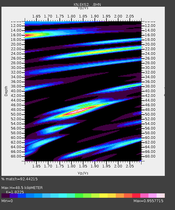
EKS2 KN.EKS2 - Earthquake Result Viewer
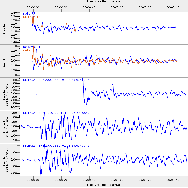
Earthquake location: New Britain Region, P.N.G.
Earthquake latitude/longitude: -5.7/151.1
Earthquake time(UTC): 2000/12/21 (356) 01:01:27 GMT
Earthquake Depth: 33 km
Earthquake Magnitude: 6.4 MB, 6.5 MS, 6.4 MW, 6.4 MW
Earthquake Catalog/Contributor: WHDF/NEIC
Network: KN Kyrgyz Seismic Telemetry Network
Station: EKS2 KN.EKS2
Lat/Lon: 42.66 N/73.78 E
Elevation: 1360 m
Distance: 84.6 deg
Az: 313.704 deg
Baz: 102.77 deg
Ray Param: 0.04532364
Estimated Moho Depth: 48.5 km
Estimated Crust Vp/Vs: 1.82
Assumed Crust Vp: 6.316 km/s
Estimated Crust Vs: 3.465 km/s
Estimated Crust Poisson's Ratio: 0.28
Radial Match: 92.44215 %
Radial Bump: 400
Transverse Match: 88.91119 %
Transverse Bump: 400
SOD ConfigId: 3744
Insert Time: 2010-03-08 19:41:17.264 +0000
GWidth: 2.5
Max Bumps: 400
Tol: 0.001

Signal To Noise

ChannelStoNSTALTA
KN:EKS2: :BHN:20001221T01:13:26.624004Z1.78513091.5815344E-78.8594874E-8
KN:EKS2: :BHE:20001221T01:13:26.624004Z1.48479669.0914995E-86.12306E-8
KN:EKS2: :BHZ:20001221T01:13:26.624004Z4.77046063.77748E-77.91848E-8
Arrivals
Ps6.5 SECOND
PpPs21 SECOND
PsPs/PpSs28 SECOND