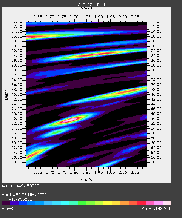
EKS2 KN.EKS2 - Earthquake Result Viewer
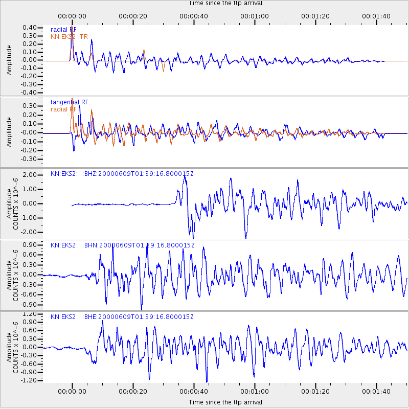
Earthquake location: New Britain Region, P.N.G.
Earthquake latitude/longitude: -5.1/152.5
Earthquake time(UTC): 2000/06/09 (161) 01:27:15 GMT
Earthquake Depth: 33 km
Earthquake Magnitude: 5.4 MB, 6.3 MS, 6.3 MW, 6.3 MW
Earthquake Catalog/Contributor: WHDF/NEIC
Network: KN Kyrgyz Seismic Telemetry Network
Station: EKS2 KN.EKS2
Lat/Lon: 42.66 N/73.78 E
Elevation: 1360 m
Distance: 85.2 deg
Az: 313.45 deg
Baz: 101.365 deg
Ray Param: 0.04492464
Estimated Moho Depth: 50.25 km
Estimated Crust Vp/Vs: 1.79
Assumed Crust Vp: 6.316 km/s
Estimated Crust Vs: 3.538 km/s
Estimated Crust Poisson's Ratio: 0.27
Radial Match: 94.59082 %
Radial Bump: 400
Transverse Match: 90.53733 %
Transverse Bump: 400
SOD ConfigId: 3744
Insert Time: 2010-03-08 19:41:36.478 +0000
GWidth: 2.5
Max Bumps: 400
Tol: 0.001

Signal To Noise

ChannelStoNSTALTA
KN:EKS2: :BHN:20000609T01:39:16.800015Z0.360670951.5443346E-84.2818378E-8
KN:EKS2: :BHE:20000609T01:39:16.800015Z1.4948415.5454674E-83.7097372E-8
KN:EKS2: :BHZ:20000609T01:39:16.800015Z9.3438672.5954057E-72.777657E-8
Arrivals
Ps6.4 SECOND
PpPs22 SECOND
PsPs/PpSs28 SECOND