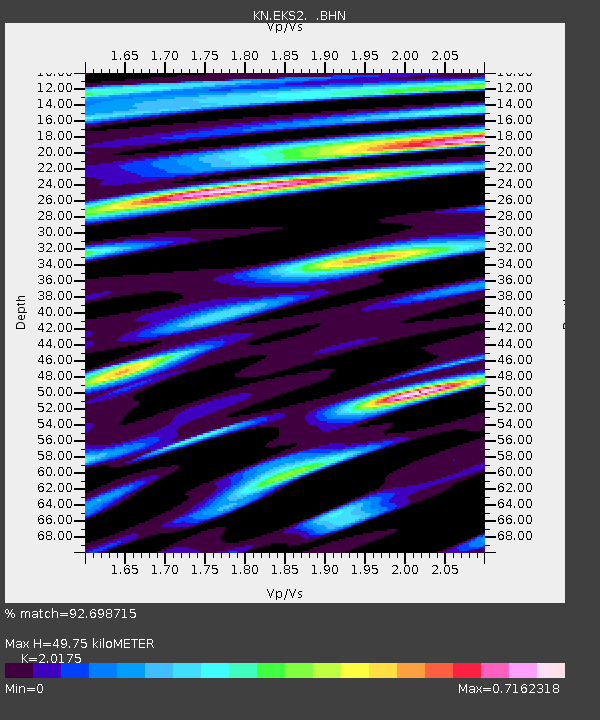
EKS2 KN.EKS2 - Earthquake Result Viewer
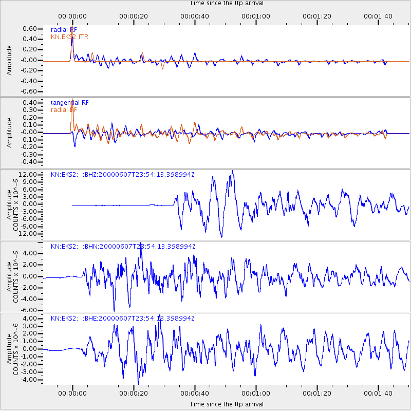
Earthquake location: Southern Sumatra, Indonesia
Earthquake latitude/longitude: -4.6/101.9
Earthquake time(UTC): 2000/06/07 (159) 23:45:26 GMT
Earthquake Depth: 33 km
Earthquake Magnitude: 6.1 MB, 6.7 MS, 6.7 MW, 6.5 MW
Earthquake Catalog/Contributor: WHDF/NEIC
Network: KN Kyrgyz Seismic Telemetry Network
Station: EKS2 KN.EKS2
Lat/Lon: 42.66 N/73.78 E
Elevation: 1360 m
Distance: 53.5 deg
Az: 334.375 deg
Baz: 144.237 deg
Ray Param: 0.065980785
Estimated Moho Depth: 49.75 km
Estimated Crust Vp/Vs: 2.02
Assumed Crust Vp: 6.316 km/s
Estimated Crust Vs: 3.13 km/s
Estimated Crust Poisson's Ratio: 0.34
Radial Match: 92.698715 %
Radial Bump: 400
Transverse Match: 87.41095 %
Transverse Bump: 400
SOD ConfigId: 3744
Insert Time: 2010-03-08 19:41:39.959 +0000
GWidth: 2.5
Max Bumps: 400
Tol: 0.001

Signal To Noise

ChannelStoNSTALTA
KN:EKS2: :BHN:20000607T23:54:13.398994Z4.7277914.860975E-71.02817054E-7
KN:EKS2: :BHE:20000607T23:54:13.398994Z3.69786883.0851334E-78.343004E-8
KN:EKS2: :BHZ:20000607T23:54:13.398994Z17.4195371.450889E-68.3290914E-8
Arrivals
Ps8.4 SECOND
PpPs23 SECOND
PsPs/PpSs31 SECOND