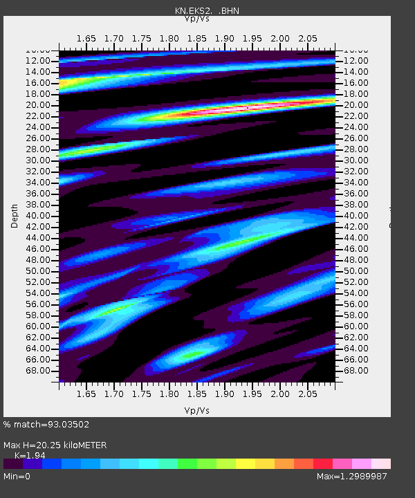
EKS2 KN.EKS2 - Earthquake Result Viewer
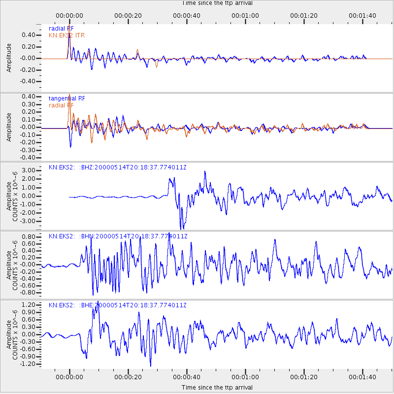
Earthquake location: Banda Sea
Earthquake latitude/longitude: -4.3/123.2
Earthquake time(UTC): 2000/05/14 (135) 20:08:34 GMT
Earthquake Depth: 33 km
Earthquake Magnitude: 5.9 MB, 5.9 MS, 6.3 MW, 6.2 MW
Earthquake Catalog/Contributor: WHDF/NEIC
Network: KN Kyrgyz Seismic Telemetry Network
Station: EKS2 KN.EKS2
Lat/Lon: 42.66 N/73.78 E
Elevation: 1360 m
Distance: 64.6 deg
Az: 321.701 deg
Baz: 123.084 deg
Ray Param: 0.05875201
Estimated Moho Depth: 20.25 km
Estimated Crust Vp/Vs: 1.94
Assumed Crust Vp: 6.316 km/s
Estimated Crust Vs: 3.255 km/s
Estimated Crust Poisson's Ratio: 0.32
Radial Match: 93.03502 %
Radial Bump: 400
Transverse Match: 88.95499 %
Transverse Bump: 400
SOD ConfigId: 3744
Insert Time: 2010-03-08 19:41:45.947 +0000
GWidth: 2.5
Max Bumps: 400
Tol: 0.001

Signal To Noise

ChannelStoNSTALTA
KN:EKS2: :BHN:20000514T20:18:37.774011Z1.79681919.202709E-85.1216674E-8
KN:EKS2: :BHE:20000514T20:18:37.774011Z4.97960422.6293353E-75.280209E-8
KN:EKS2: :BHZ:20000514T20:18:37.774011Z13.2439638.266205E-76.241489E-8
Arrivals
Ps3.1 SECOND
PpPs9.1 SECOND
PsPs/PpSs12 SECOND