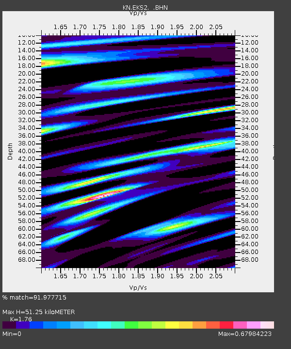
EKS2 KN.EKS2 - Earthquake Result Viewer
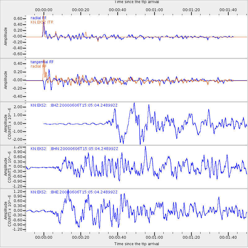
Earthquake location: Southeast Of Ryukyu Islands
Earthquake latitude/longitude: 29.4/131.4
Earthquake time(UTC): 2000/06/06 (158) 14:57:02 GMT
Earthquake Depth: 33 km
Earthquake Magnitude: 5.8 MB, 6.0 MS, 6.4 MW, 6.4 MW
Earthquake Catalog/Contributor: WHDF/NEIC
Network: KN Kyrgyz Seismic Telemetry Network
Station: EKS2 KN.EKS2
Lat/Lon: 42.66 N/73.78 E
Elevation: 1360 m
Distance: 47.6 deg
Az: 302.444 deg
Baz: 86.484 deg
Ray Param: 0.06982818
Estimated Moho Depth: 51.25 km
Estimated Crust Vp/Vs: 1.76
Assumed Crust Vp: 6.316 km/s
Estimated Crust Vs: 3.588 km/s
Estimated Crust Poisson's Ratio: 0.26
Radial Match: 91.977715 %
Radial Bump: 400
Transverse Match: 85.69763 %
Transverse Bump: 400
SOD ConfigId: 3744
Insert Time: 2010-03-08 19:41:55.506 +0000
GWidth: 2.5
Max Bumps: 400
Tol: 0.001

Signal To Noise

ChannelStoNSTALTA
KN:EKS2: :BHN:20000606T15:05:04.248992Z0.270028261.12515774E-84.1668148E-8
KN:EKS2: :BHE:20000606T15:05:04.248992Z1.20347154.404118E-83.6595114E-8
KN:EKS2: :BHZ:20000606T15:05:04.248992Z2.2495669.65009E-84.2897558E-8
Arrivals
Ps6.5 SECOND
PpPs21 SECOND
PsPs/PpSs28 SECOND