You are here: Home > Network List > UU - University of Utah Regional Network Stations List
> Station BSUT Blindstream Canyon, Hanna, UT, USA > Earthquake Result Viewer
BSUT Blindstream Canyon, Hanna, UT, USA - Earthquake Result Viewer
| Earthquake location: |
Fox Islands, Aleutian Islands |
| Earthquake latitude/longitude: |
52.4/-166.7 |
| Earthquake time(UTC): |
2017/05/24 (144) 16:36:01 GMT |
| Earthquake Depth: |
2.0 km |
| Earthquake Magnitude: |
5.7 Mi |
| Earthquake Catalog/Contributor: |
NEIC PDE/at |
|
| Network: |
UU University of Utah Regional Network |
| Station: |
BSUT Blindstream Canyon, Hanna, UT, USA |
| Lat/Lon: |
40.54 N/110.76 W |
| Elevation: |
3211 m |
|
| Distance: |
39.4 deg |
| Az: |
84.65 deg |
| Baz: |
306.861 deg |
| Ray Param: |
0.07504885 |
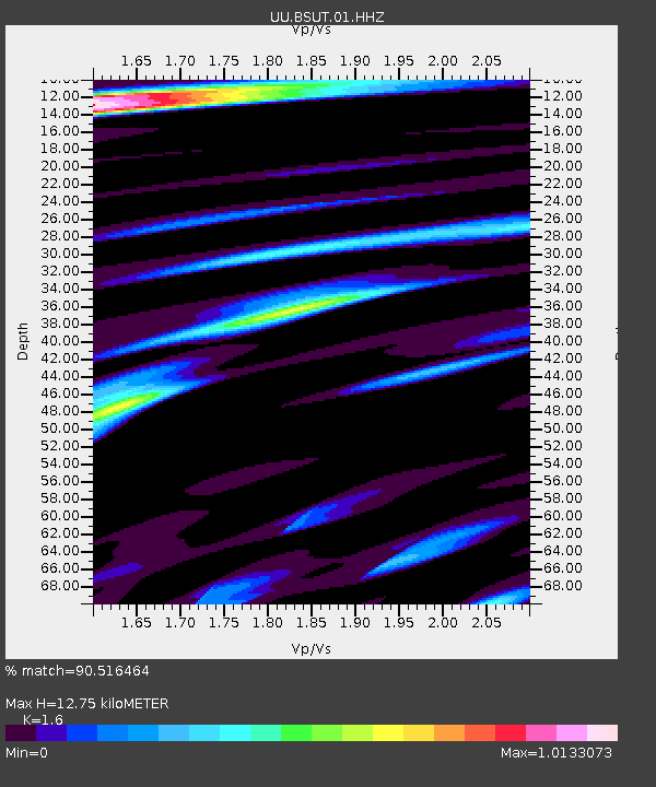
| Estimated Moho Depth: |
12.75 km |
| Estimated Crust Vp/Vs: |
1.60 |
| Assumed Crust Vp: |
6.155 km/s |
| Estimated Crust Vs: |
3.847 km/s |
| Estimated Crust Poisson's Ratio: |
0.18 |
|
| Radial Match: |
90.516464 % |
| Radial Bump: |
400 |
| Transverse Match: |
82.95667 % |
| Transverse Bump: |
400 |
| SOD ConfigId: |
2028011 |
| Insert Time: |
2017-06-07 16:44:28.896 +0000 |
| GWidth: |
2.5 |
| Max Bumps: |
400 |
| Tol: |
0.001 |
|

Signal To Noise
| Channel | StoN | STA | LTA |
| UU:BSUT:01:HHZ:20170524T16:43:00.888Z | 16.880106 | 4.2675225E-8 | 2.5281373E-9 |
| UU:BSUT:01:HHN:20170524T16:43:00.888Z | 6.7005544 | 1.7674028E-8 | 2.6376963E-9 |
| UU:BSUT:01:HHE:20170524T16:43:00.888Z | 7.2444253 | 2.0310722E-8 | 2.8036347E-9 |
| Arrivals |
| Ps | 1.3 SECOND |
| PpPs | 5.0 SECOND |
| PsPs/PpSs | 6.3 SECOND |


