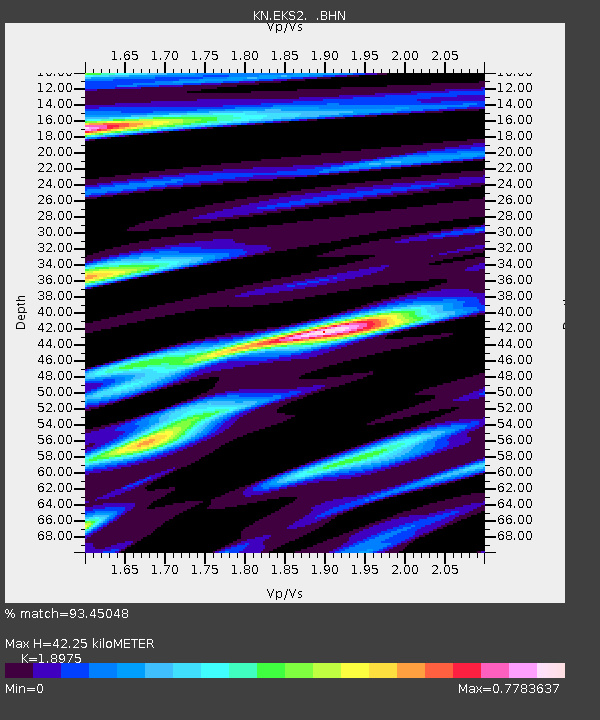
EKS2 KN.EKS2 - Earthquake Result Viewer
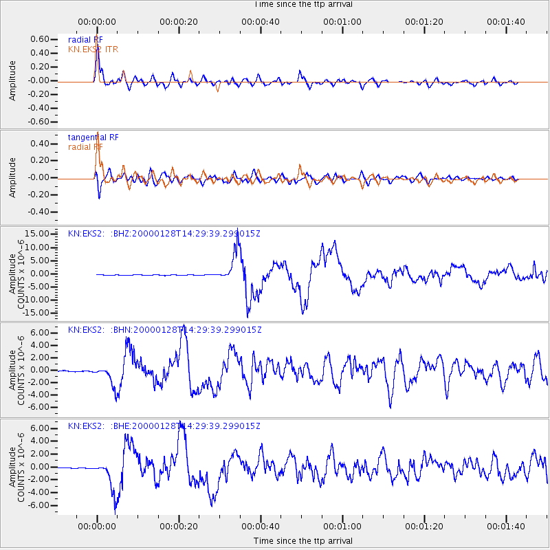
Earthquake location: Kuril Islands
Earthquake latitude/longitude: 43.0/146.8
Earthquake time(UTC): 2000/01/28 (028) 14:21:07 GMT
Earthquake Depth: 61 km
Earthquake Magnitude: 6.7 MB, 6.6 MS, 6.8 MW, 6.8 ME
Earthquake Catalog/Contributor: WHDF/NEIC
Network: KN Kyrgyz Seismic Telemetry Network
Station: EKS2 KN.EKS2
Lat/Lon: 42.66 N/73.78 E
Elevation: 1360 m
Distance: 51.9 deg
Az: 296.304 deg
Baz: 62.991 deg
Ray Param: 0.06692794
Estimated Moho Depth: 42.25 km
Estimated Crust Vp/Vs: 1.90
Assumed Crust Vp: 6.316 km/s
Estimated Crust Vs: 3.328 km/s
Estimated Crust Poisson's Ratio: 0.31
Radial Match: 93.45048 %
Radial Bump: 400
Transverse Match: 86.16041 %
Transverse Bump: 400
SOD ConfigId: 3744
Insert Time: 2010-03-08 19:42:04.737 +0000
GWidth: 2.5
Max Bumps: 400
Tol: 0.001

Signal To Noise

ChannelStoNSTALTA
KN:EKS2: :BHN:20000128T14:29:39.299015Z12.0780891.7466455E-61.4461274E-7
KN:EKS2: :BHE:20000128T14:29:39.299015Z34.343052.5368809E-67.386884E-8
KN:EKS2: :BHZ:20000128T14:29:39.299015Z55.3361786.201268E-61.1206535E-7
Arrivals
Ps6.3 SECOND
PpPs18 SECOND
PsPs/PpSs25 SECOND