You are here: Home > Network List > UU - University of Utah Regional Network Stations List
> Station LIUT Lila Canyon, UT, USA > Earthquake Result Viewer
LIUT Lila Canyon, UT, USA - Earthquake Result Viewer
| Earthquake location: |
Fox Islands, Aleutian Islands |
| Earthquake latitude/longitude: |
52.4/-166.7 |
| Earthquake time(UTC): |
2017/05/24 (144) 16:36:01 GMT |
| Earthquake Depth: |
2.0 km |
| Earthquake Magnitude: |
5.7 Mi |
| Earthquake Catalog/Contributor: |
NEIC PDE/at |
|
| Network: |
UU University of Utah Regional Network |
| Station: |
LIUT Lila Canyon, UT, USA |
| Lat/Lon: |
39.42 N/110.33 W |
| Elevation: |
2178 m |
|
| Distance: |
40.3 deg |
| Az: |
85.71 deg |
| Baz: |
307.954 deg |
| Ray Param: |
0.074493945 |
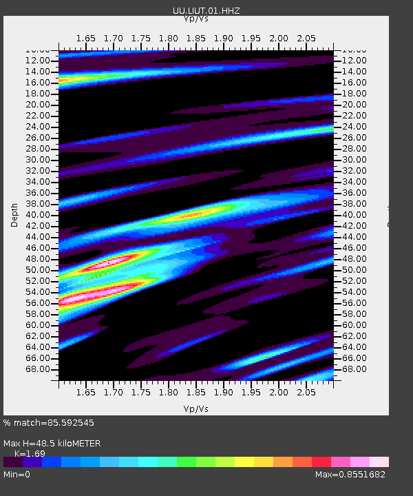
| Estimated Moho Depth: |
48.5 km |
| Estimated Crust Vp/Vs: |
1.69 |
| Assumed Crust Vp: |
6.207 km/s |
| Estimated Crust Vs: |
3.673 km/s |
| Estimated Crust Poisson's Ratio: |
0.23 |
|
| Radial Match: |
85.592545 % |
| Radial Bump: |
400 |
| Transverse Match: |
70.47257 % |
| Transverse Bump: |
400 |
| SOD ConfigId: |
2028011 |
| Insert Time: |
2017-06-07 16:44:45.221 +0000 |
| GWidth: |
2.5 |
| Max Bumps: |
400 |
| Tol: |
0.001 |
|

Signal To Noise
| Channel | StoN | STA | LTA |
| UU:LIUT:01:HHZ:20170524T16:43:08.700012Z | 13.315313 | 4.7358384E-8 | 3.5566858E-9 |
| UU:LIUT:01:HHN:20170524T16:43:08.700012Z | 3.7770536 | 1.5507233E-8 | 4.1056425E-9 |
| UU:LIUT:01:HHE:20170524T16:43:08.700012Z | 7.6343026 | 2.5838675E-8 | 3.3845495E-9 |
| Arrivals |
| Ps | 5.8 SECOND |
| PpPs | 20 SECOND |
| PsPs/PpSs | 25 SECOND |


