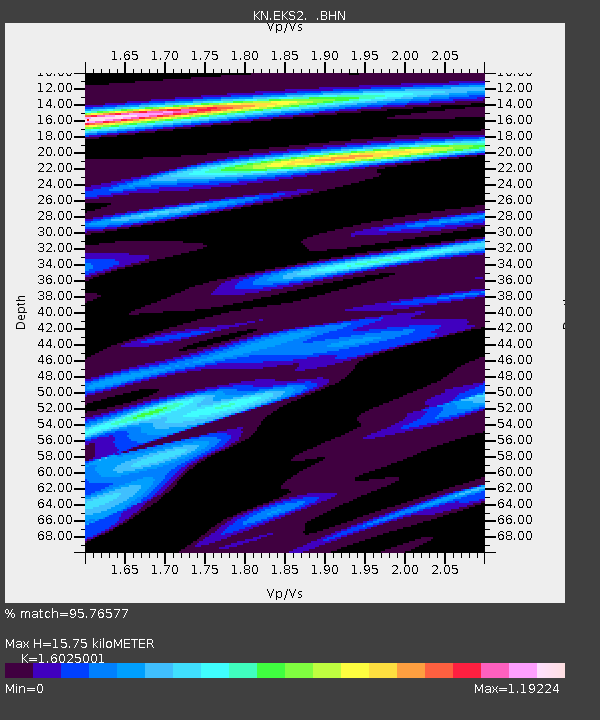
EKS2 KN.EKS2 - Earthquake Result Viewer
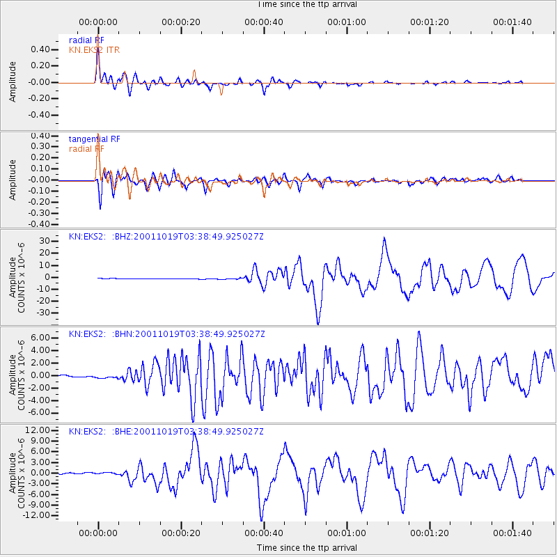
Earthquake location: Banda Sea
Earthquake latitude/longitude: -4.1/123.9
Earthquake time(UTC): 2001/10/19 (292) 03:28:44 GMT
Earthquake Depth: 33 km
Earthquake Magnitude: 6.3 MB, 7.3 MS, 7.5 MW, 7.4 MW
Earthquake Catalog/Contributor: WHDF/NEIC
Network: KN Kyrgyz Seismic Telemetry Network
Station: EKS2 KN.EKS2
Lat/Lon: 42.66 N/73.78 E
Elevation: 1360 m
Distance: 64.9 deg
Az: 321.318 deg
Baz: 122.31 deg
Ray Param: 0.058550656
Estimated Moho Depth: 15.75 km
Estimated Crust Vp/Vs: 1.60
Assumed Crust Vp: 6.316 km/s
Estimated Crust Vs: 3.941 km/s
Estimated Crust Poisson's Ratio: 0.18
Radial Match: 95.76577 %
Radial Bump: 400
Transverse Match: 93.069145 %
Transverse Bump: 400
SOD ConfigId: 20082
Insert Time: 2010-03-08 19:42:35.616 +0000
GWidth: 2.5
Max Bumps: 400
Tol: 0.001

Signal To Noise

ChannelStoNSTALTA
KN:EKS2: :BHN:20011019T03:38:49.925027Z1.38937213.229817E-72.3246594E-7
KN:EKS2: :BHE:20011019T03:38:49.925027Z1.37188034.094835E-72.984834E-7
KN:EKS2: :BHZ:20011019T03:38:49.925027Z3.1344844.753253E-71.5164387E-7
Arrivals
Ps1.6 SECOND
PpPs6.2 SECOND
PsPs/PpSs7.8 SECOND