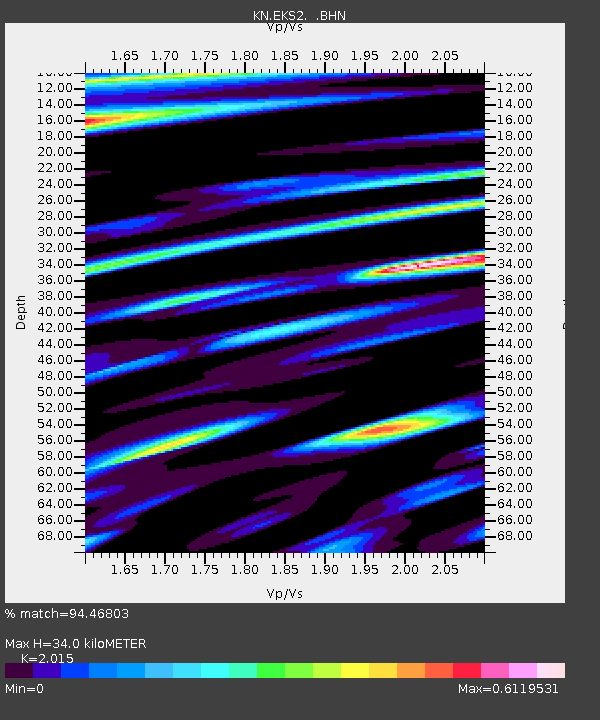
EKS2 KN.EKS2 - Earthquake Result Viewer
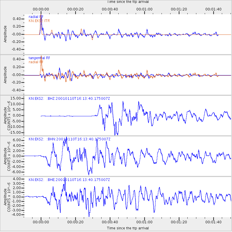
Earthquake location: Kodiak Island Region, Alaska
Earthquake latitude/longitude: 57.1/-153.2
Earthquake time(UTC): 2001/01/10 (010) 16:02:44 GMT
Earthquake Depth: 33 km
Earthquake Magnitude: 6.2 MB, 6.8 MS, 7.1 MW, 6.8 ML
Earthquake Catalog/Contributor: WHDF/NEIC
Network: KN Kyrgyz Seismic Telemetry Network
Station: EKS2 KN.EKS2
Lat/Lon: 42.66 N/73.78 E
Elevation: 1360 m
Distance: 73.1 deg
Az: 325.685 deg
Baz: 24.667 deg
Ray Param: 0.053185217
Estimated Moho Depth: 34.0 km
Estimated Crust Vp/Vs: 2.02
Assumed Crust Vp: 6.316 km/s
Estimated Crust Vs: 3.134 km/s
Estimated Crust Poisson's Ratio: 0.34
Radial Match: 94.46803 %
Radial Bump: 400
Transverse Match: 91.600365 %
Transverse Bump: 400
SOD ConfigId: 3744
Insert Time: 2010-03-08 19:43:01.198 +0000
GWidth: 2.5
Max Bumps: 400
Tol: 0.001

Signal To Noise

ChannelStoNSTALTA
KN:EKS2: :BHN:20010110T16:13:40.175007Z3.85804181.2608194E-63.2680293E-7
KN:EKS2: :BHE:20010110T16:13:40.175007Z2.45652635.333001E-72.1709523E-7
KN:EKS2: :BHZ:20010110T16:13:40.175007Z37.4088943.831368E-61.0241863E-7
Arrivals
Ps5.6 SECOND
PpPs16 SECOND
PsPs/PpSs21 SECOND