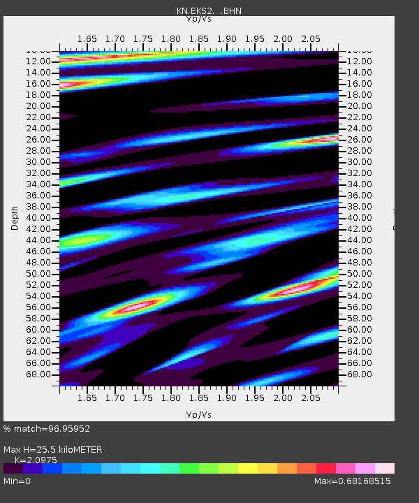
EKS2 KN.EKS2 - Earthquake Result Viewer
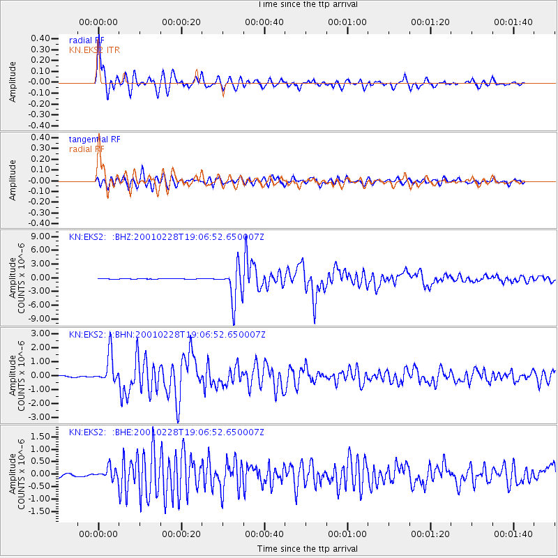
Earthquake location: Washington
Earthquake latitude/longitude: 47.1/-122.7
Earthquake time(UTC): 2001/02/28 (059) 18:54:32 GMT
Earthquake Depth: 52 km
Earthquake Magnitude: 6.5 MB, 6.6 MS, 6.8 MW, 6.7 ME
Earthquake Catalog/Contributor: WHDF/NEIC
Network: KN Kyrgyz Seismic Telemetry Network
Station: EKS2 KN.EKS2
Lat/Lon: 42.66 N/73.78 E
Elevation: 1360 m
Distance: 89.4 deg
Az: 347.903 deg
Baz: 11.181 deg
Ray Param: 0.041804373
Estimated Moho Depth: 25.5 km
Estimated Crust Vp/Vs: 2.10
Assumed Crust Vp: 6.316 km/s
Estimated Crust Vs: 3.011 km/s
Estimated Crust Poisson's Ratio: 0.35
Radial Match: 96.95952 %
Radial Bump: 400
Transverse Match: 92.73218 %
Transverse Bump: 400
SOD ConfigId: 4714
Insert Time: 2010-03-08 19:43:07.980 +0000
GWidth: 2.5
Max Bumps: 400
Tol: 0.001

Signal To Noise

ChannelStoNSTALTA
KN:EKS2: :BHN:20010228T19:06:52.650007Z17.6640051.0947697E-66.1977424E-8
KN:EKS2: :BHE:20010228T19:06:52.650007Z4.24238972.3758531E-75.6002712E-8
KN:EKS2: :BHZ:20010228T19:06:52.650007Z89.2457053.938902E-64.4135476E-8
Arrivals
Ps4.5 SECOND
PpPs12 SECOND
PsPs/PpSs17 SECOND