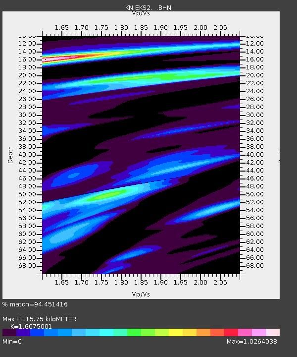
EKS2 KN.EKS2 - Earthquake Result Viewer
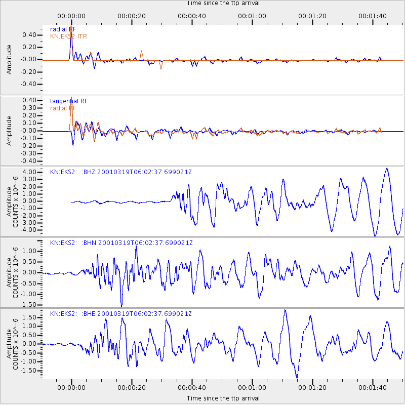
Earthquake location: Banda Sea
Earthquake latitude/longitude: -4.0/128.0
Earthquake time(UTC): 2001/03/19 (078) 05:52:15 GMT
Earthquake Depth: 33 km
Earthquake Magnitude: 6.0 MB, 6.5 MS, 6.5 MW, 6.5 MW
Earthquake Catalog/Contributor: WHDF/NEIC
Network: KN Kyrgyz Seismic Telemetry Network
Station: EKS2 KN.EKS2
Lat/Lon: 42.66 N/73.78 E
Elevation: 1360 m
Distance: 67.5 deg
Az: 319.612 deg
Baz: 118.802 deg
Ray Param: 0.056872047
Estimated Moho Depth: 15.75 km
Estimated Crust Vp/Vs: 1.61
Assumed Crust Vp: 6.316 km/s
Estimated Crust Vs: 3.929 km/s
Estimated Crust Poisson's Ratio: 0.18
Radial Match: 94.451416 %
Radial Bump: 400
Transverse Match: 90.667366 %
Transverse Bump: 400
SOD ConfigId: 4714
Insert Time: 2010-03-08 19:43:09.485 +0000
GWidth: 2.5
Max Bumps: 400
Tol: 0.001

Signal To Noise

ChannelStoNSTALTA
KN:EKS2: :BHN:20010319T06:02:37.699021Z1.56191077.7004835E-84.930169E-8
KN:EKS2: :BHE:20010319T06:02:37.699021Z3.48587471.2396367E-73.5561712E-8
KN:EKS2: :BHZ:20010319T06:02:37.699021Z4.725954.3786625E-79.2651476E-8
Arrivals
Ps1.6 SECOND
PpPs6.2 SECOND
PsPs/PpSs7.8 SECOND