You are here: Home > Network List > UU - University of Utah Regional Network Stations List
> Station TMU Trail Mountain (BB), UT, USA > Earthquake Result Viewer
TMU Trail Mountain (BB), UT, USA - Earthquake Result Viewer
| Earthquake location: |
Fox Islands, Aleutian Islands |
| Earthquake latitude/longitude: |
52.4/-166.7 |
| Earthquake time(UTC): |
2017/05/24 (144) 16:36:01 GMT |
| Earthquake Depth: |
2.0 km |
| Earthquake Magnitude: |
5.7 Mi |
| Earthquake Catalog/Contributor: |
NEIC PDE/at |
|
| Network: |
UU University of Utah Regional Network |
| Station: |
TMU Trail Mountain (BB), UT, USA |
| Lat/Lon: |
39.30 N/111.21 W |
| Elevation: |
2731 m |
|
| Distance: |
39.8 deg |
| Az: |
86.52 deg |
| Baz: |
308.016 deg |
| Ray Param: |
0.07476947 |
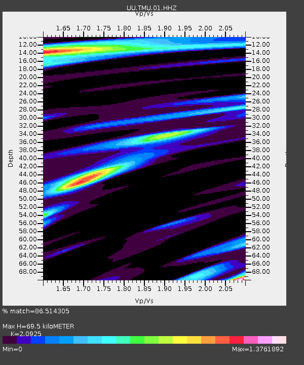
| Estimated Moho Depth: |
69.5 km |
| Estimated Crust Vp/Vs: |
2.09 |
| Assumed Crust Vp: |
6.207 km/s |
| Estimated Crust Vs: |
2.966 km/s |
| Estimated Crust Poisson's Ratio: |
0.35 |
|
| Radial Match: |
86.514305 % |
| Radial Bump: |
396 |
| Transverse Match: |
83.95297 % |
| Transverse Bump: |
343 |
| SOD ConfigId: |
2028011 |
| Insert Time: |
2017-06-07 16:45:06.507 +0000 |
| GWidth: |
2.5 |
| Max Bumps: |
400 |
| Tol: |
0.001 |
|

Signal To Noise
| Channel | StoN | STA | LTA |
| UU:TMU:01:HHZ:20170524T16:43:04.880005Z | 12.26463 | 4.5030973E-8 | 3.6716128E-9 |
| UU:TMU:01:HHN:20170524T16:43:04.880005Z | 3.5110557 | 1.4897278E-8 | 4.2429624E-9 |
| UU:TMU:01:HHE:20170524T16:43:04.880005Z | 6.2050867 | 2.2338426E-8 | 3.6000183E-9 |
| Arrivals |
| Ps | 13 SECOND |
| PpPs | 33 SECOND |
| PsPs/PpSs | 46 SECOND |


