You are here: Home > Network List > TS - TERRAscope (Southern California Seismic Network) Stations List
> Station SBC Santa Barbara, California, USA > Earthquake Result Viewer
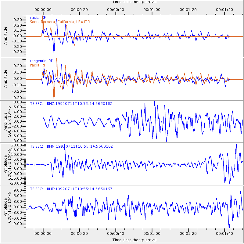
SBC Santa Barbara, California, USA - Earthquake Result Viewer
*The percent match for this event was below the threshold and hence no stack was calculated.
| Earthquake location: |
South Of Fiji Islands |
| Earthquake latitude/longitude: |
-22.3/-178.5 |
| Earthquake time(UTC): |
1992/07/11 (193) 10:44:20 GMT |
| Earthquake Depth: |
381 km |
| Earthquake Magnitude: |
6.2 MB |
| Earthquake Catalog/Contributor: |
WHDF/NEIC |
|
| Network: |
TS TERRAscope (Southern California Seismic Network) |
| Station: |
SBC Santa Barbara, California, USA |
| Lat/Lon: |
34.44 N/119.71 W |
| Elevation: |
90 m |
|
| Distance: |
79.4 deg |
| Az: |
45.989 deg |
| Baz: |
233.707 deg |
| Ray Param: |
$rayparam |
*The percent match for this event was below the threshold and hence was not used in the summary stack. |
|
| Radial Match: |
72.33462 % |
| Radial Bump: |
342 |
| Transverse Match: |
68.974785 % |
| Transverse Bump: |
295 |
| SOD ConfigId: |
4480 |
| Insert Time: |
2010-02-26 14:49:00.318 +0000 |
| GWidth: |
2.5 |
| Max Bumps: |
400 |
| Tol: |
0.001 |
|
Signal To Noise
| Channel | StoN | STA | LTA |
| TS:SBC: :BHN:19920711T10:55:14.566016Z | 2.5393472 | 1.3414596E-6 | 5.282695E-7 |
| TS:SBC: :BHE:19920711T10:55:14.566016Z | 1.0579933 | 1.1898392E-6 | 1.124619E-6 |
| TS:SBC: :BHZ:19920711T10:55:14.566016Z | 0.93470806 | 1.0957067E-6 | 1.1722448E-6 |
| Arrivals |
| Ps | |
| PpPs | |
| PsPs/PpSs | |


