EKS2 KN.EKS2 - Earthquake Result Viewer
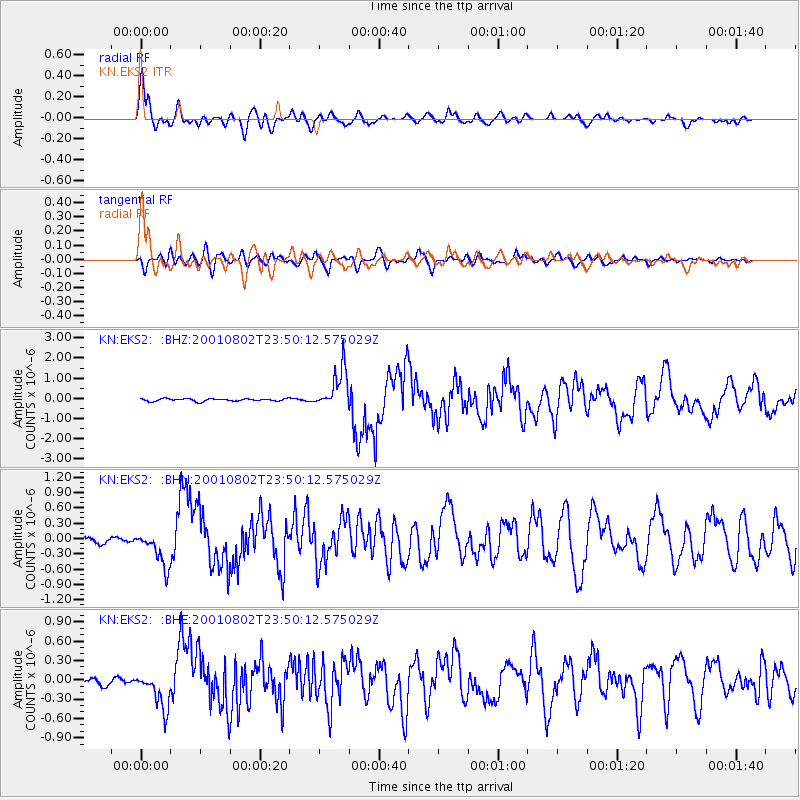
Earthquake location: Near East Coast Of Kamchatka
Earthquake latitude/longitude: 56.3/163.8
Earthquake time(UTC): 2001/08/02 (214) 23:41:06 GMT
Earthquake Depth: 14 km
Earthquake Magnitude: 5.9 MB, 6.2 MS, 6.3 MW, 6.2 ME
Earthquake Catalog/Contributor: WHDF/NEIC
Network: KN Kyrgyz Seismic Telemetry Network
Station: EKS2 KN.EKS2
Lat/Lon: 42.66 N/73.78 E
Elevation: 1360 m
Distance: 55.9 deg
Az: 297.065 deg
Baz: 42.348 deg
Ray Param: 0.064463764
Estimated Moho Depth: 10.25 km
Estimated Crust Vp/Vs: 1.78
Assumed Crust Vp: 6.316 km/s
Estimated Crust Vs: 3.553 km/s
Estimated Crust Poisson's Ratio: 0.27
Radial Match: 95.80998 %
Radial Bump: 400
Transverse Match: 79.31348 %
Transverse Bump: 400
SOD ConfigId: 3753
Insert Time: 2010-03-08 19:43:44.156 +0000
GWidth: 2.5
Max Bumps: 400
Tol: 0.001

Signal To Noise

ChannelStoNSTALTA
KN:EKS2: :BHN:20010802T23:50:12.575029Z7.7274413.4606597E-74.4784034E-8
KN:EKS2: :BHE:20010802T23:50:12.575029Z7.5365742.8720572E-73.810826E-8
KN:EKS2: :BHZ:20010802T23:50:12.575029Z16.1528229.825316E-76.082723E-8
Arrivals
Ps1.3 SECOND
PpPs4.3 SECOND
PsPs/PpSs5.6 SECOND