You are here: Home > Network List > TA - USArray Transportable Network (new EarthScope stations) Stations List
> Station C18K Utukok River, AK, USA > Earthquake Result Viewer
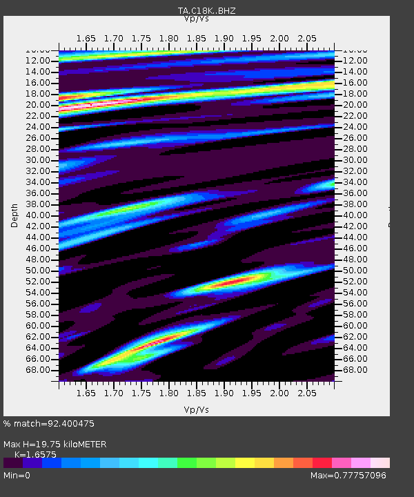
C18K Utukok River, AK, USA - Earthquake Result Viewer
| Earthquake location: |
Crete, Greece |
| Earthquake latitude/longitude: |
34.2/25.7 |
| Earthquake time(UTC): |
2020/05/02 (123) 12:51:06 GMT |
| Earthquake Depth: |
17 km |
| Earthquake Magnitude: |
6.6 mww |
| Earthquake Catalog/Contributor: |
NEIC PDE/us |
|
| Network: |
TA USArray Transportable Network (new EarthScope stations) |
| Station: |
C18K Utukok River, AK, USA |
| Lat/Lon: |
68.65 N/161.19 W |
| Elevation: |
845 m |
|
| Distance: |
77.3 deg |
| Az: |
2.587 deg |
| Baz: |
354.137 deg |
| Ray Param: |
0.050385226 |
| Estimated Moho Depth: |
19.75 km |
| Estimated Crust Vp/Vs: |
1.66 |
| Assumed Crust Vp: |
5.906 km/s |
| Estimated Crust Vs: |
3.563 km/s |
| Estimated Crust Poisson's Ratio: |
0.21 |
|
| Radial Match: |
92.400475 % |
| Radial Bump: |
400 |
| Transverse Match: |
87.15697 % |
| Transverse Bump: |
400 |
| SOD ConfigId: |
21166931 |
| Insert Time: |
2020-05-16 13:13:25.377 +0000 |
| GWidth: |
2.5 |
| Max Bumps: |
400 |
| Tol: |
0.001 |
|

Signal To Noise
| Channel | StoN | STA | LTA |
| TA:C18K: :BHZ:20200502T13:02:28.925Z | 21.918652 | 1.4682223E-6 | 6.6985066E-8 |
| TA:C18K: :BHN:20200502T13:02:28.925Z | 7.1105456 | 4.0003349E-7 | 5.6259182E-8 |
| TA:C18K: :BHE:20200502T13:02:28.925Z | 3.0796282 | 1.0767957E-7 | 3.496512E-8 |
| Arrivals |
| Ps | 2.3 SECOND |
| PpPs | 8.6 SECOND |
| PsPs/PpSs | 11 SECOND |


