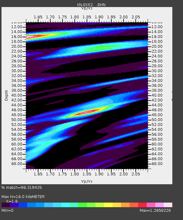
EKS2 KN.EKS2 - Earthquake Result Viewer
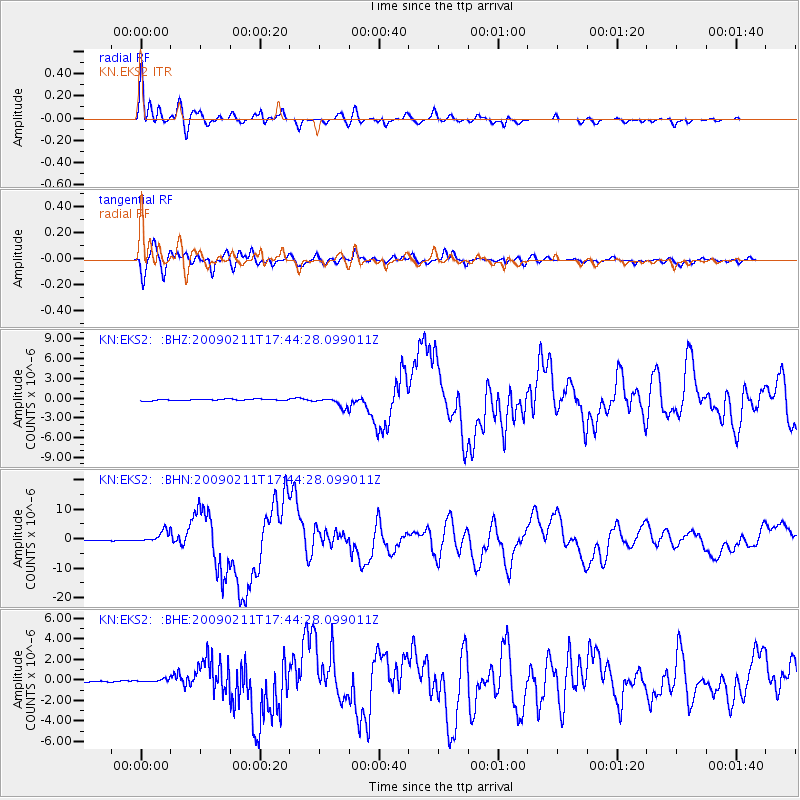
Earthquake location: Talaud Islands, Indonesia
Earthquake latitude/longitude: 3.9/126.4
Earthquake time(UTC): 2009/02/11 (042) 17:34:50 GMT
Earthquake Depth: 22 km
Earthquake Magnitude: 6.6 MB, 7.2 MS, 7.2 MW, 7.1 MW
Earthquake Catalog/Contributor: WHDF/NEIC
Network: KN Kyrgyz Seismic Telemetry Network
Station: EKS2 KN.EKS2
Lat/Lon: 42.66 N/73.78 E
Elevation: 1360 m
Distance: 60.5 deg
Az: 317.672 deg
Baz: 114.383 deg
Ray Param: 0.06145522
Estimated Moho Depth: 16.0 km
Estimated Crust Vp/Vs: 1.60
Assumed Crust Vp: 6.316 km/s
Estimated Crust Vs: 3.947 km/s
Estimated Crust Poisson's Ratio: 0.18
Radial Match: 96.319435 %
Radial Bump: 400
Transverse Match: 90.641174 %
Transverse Bump: 400
SOD ConfigId: 2658
Insert Time: 2010-03-08 19:43:56.590 +0000
GWidth: 2.5
Max Bumps: 400
Tol: 0.001

Signal To Noise

ChannelStoNSTALTA
KN:EKS2: :BHN:20090211T17:44:28.099011Z22.0982132.0485572E-69.270239E-8
KN:EKS2: :BHE:20090211T17:44:28.099011Z1.99647392.061819E-71.0327302E-7
KN:EKS2: :BHZ:20090211T17:44:28.099011Z6.12903647.413182E-71.2095184E-7
Arrivals
Ps1.6 SECOND
PpPs6.3 SECOND
PsPs/PpSs7.9 SECOND