You are here: Home > Network List > TA - USArray Transportable Network (new EarthScope stations) Stations List
> Station C26K Camden Bay, AK, USA > Earthquake Result Viewer
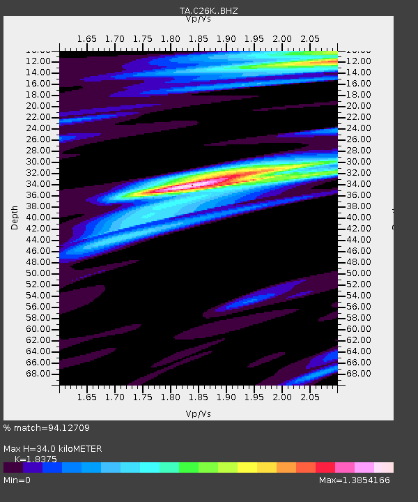
C26K Camden Bay, AK, USA - Earthquake Result Viewer
| Earthquake location: |
Crete, Greece |
| Earthquake latitude/longitude: |
34.2/25.7 |
| Earthquake time(UTC): |
2020/05/02 (123) 12:51:06 GMT |
| Earthquake Depth: |
17 km |
| Earthquake Magnitude: |
6.6 mww |
| Earthquake Catalog/Contributor: |
NEIC PDE/us |
|
| Network: |
TA USArray Transportable Network (new EarthScope stations) |
| Station: |
C26K Camden Bay, AK, USA |
| Lat/Lon: |
69.92 N/144.91 W |
| Elevation: |
139 m |
|
| Distance: |
76.0 deg |
| Az: |
356.675 deg |
| Baz: |
8.0 deg |
| Ray Param: |
0.051310558 |
| Estimated Moho Depth: |
34.0 km |
| Estimated Crust Vp/Vs: |
1.84 |
| Assumed Crust Vp: |
6.455 km/s |
| Estimated Crust Vs: |
3.513 km/s |
| Estimated Crust Poisson's Ratio: |
0.29 |
|
| Radial Match: |
94.12709 % |
| Radial Bump: |
400 |
| Transverse Match: |
92.35787 % |
| Transverse Bump: |
400 |
| SOD ConfigId: |
21166931 |
| Insert Time: |
2020-05-16 13:13:33.498 +0000 |
| GWidth: |
2.5 |
| Max Bumps: |
400 |
| Tol: |
0.001 |
|

Signal To Noise
| Channel | StoN | STA | LTA |
| TA:C26K: :BHZ:20200502T13:02:21.200025Z | 12.260027 | 1.4442237E-6 | 1.1779939E-7 |
| TA:C26K: :BHN:20200502T13:02:21.200025Z | 6.119814 | 5.231941E-7 | 8.549183E-8 |
| TA:C26K: :BHE:20200502T13:02:21.200025Z | 1.3171481 | 1.4433866E-7 | 1.09584235E-7 |
| Arrivals |
| Ps | 4.5 SECOND |
| PpPs | 14 SECOND |
| PsPs/PpSs | 19 SECOND |


