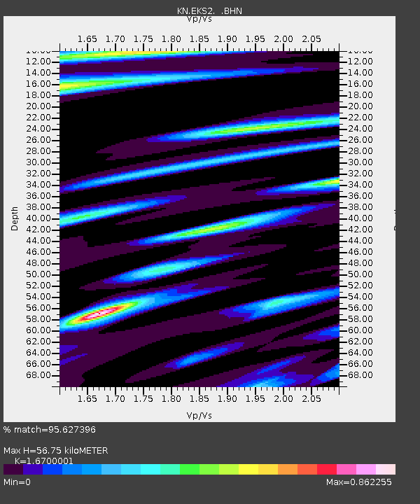
EKS2 KN.EKS2 - Earthquake Result Viewer
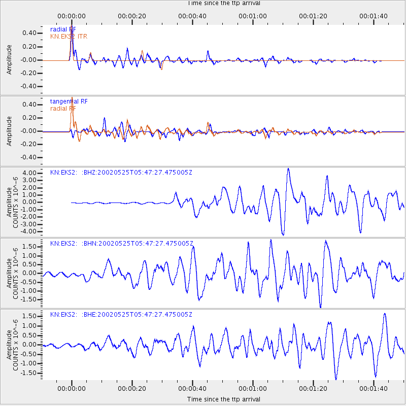
Earthquake location: South Of Alaska
Earthquake latitude/longitude: 53.8/-161.1
Earthquake time(UTC): 2002/05/25 (145) 05:36:31 GMT
Earthquake Depth: 33 km
Earthquake Magnitude: 5.5 MB, 6.1 MS, 6.5 MW, 6.4 MW
Earthquake Catalog/Contributor: WHDF/NEIC
Network: KN Kyrgyz Seismic Telemetry Network
Station: EKS2 KN.EKS2
Lat/Lon: 42.66 N/73.78 E
Elevation: 1360 m
Distance: 73.0 deg
Az: 320.878 deg
Baz: 30.48 deg
Ray Param: 0.053234693
Estimated Moho Depth: 56.75 km
Estimated Crust Vp/Vs: 1.67
Assumed Crust Vp: 6.316 km/s
Estimated Crust Vs: 3.782 km/s
Estimated Crust Poisson's Ratio: 0.22
Radial Match: 95.627396 %
Radial Bump: 397
Transverse Match: 88.87296 %
Transverse Bump: 400
SOD ConfigId: 20082
Insert Time: 2010-03-08 19:43:58.372 +0000
GWidth: 2.5
Max Bumps: 400
Tol: 0.001

Signal To Noise

ChannelStoNSTALTA
KN:EKS2: :BHN:20020525T05:47:27.475005Z2.04854371.7512791E-78.5488985E-8
KN:EKS2: :BHE:20020525T05:47:27.475005Z1.46643489.991782E-86.813656E-8
KN:EKS2: :BHZ:20020525T05:47:27.475005Z7.2599694.8333436E-76.657526E-8
Arrivals
Ps6.2 SECOND
PpPs23 SECOND
PsPs/PpSs29 SECOND