You are here: Home > Network List > TA - USArray Transportable Network (new EarthScope stations) Stations List
> Station F20K Avaraart Lake, AK, USA > Earthquake Result Viewer
F20K Avaraart Lake, AK, USA - Earthquake Result Viewer
| Earthquake location: |
Crete, Greece |
| Earthquake latitude/longitude: |
34.2/25.7 |
| Earthquake time(UTC): |
2020/05/02 (123) 12:51:06 GMT |
| Earthquake Depth: |
17 km |
| Earthquake Magnitude: |
6.6 mww |
| Earthquake Catalog/Contributor: |
NEIC PDE/us |
|
| Network: |
TA USArray Transportable Network (new EarthScope stations) |
| Station: |
F20K Avaraart Lake, AK, USA |
| Lat/Lon: |
67.05 N/155.73 W |
| Elevation: |
136 m |
|
| Distance: |
79.1 deg |
| Az: |
0.574 deg |
| Baz: |
358.787 deg |
| Ray Param: |
0.04921208 |
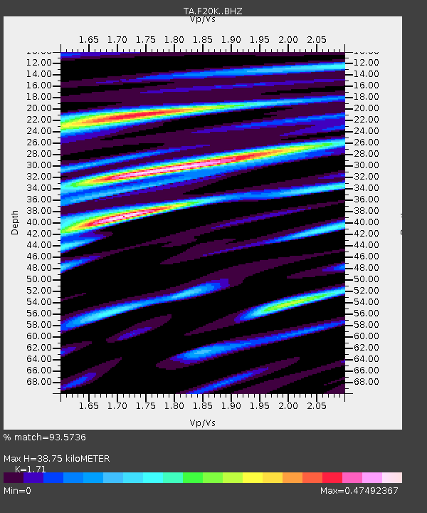
| Estimated Moho Depth: |
38.75 km |
| Estimated Crust Vp/Vs: |
1.71 |
| Assumed Crust Vp: |
6.522 km/s |
| Estimated Crust Vs: |
3.814 km/s |
| Estimated Crust Poisson's Ratio: |
0.24 |
|
| Radial Match: |
93.5736 % |
| Radial Bump: |
400 |
| Transverse Match: |
82.61391 % |
| Transverse Bump: |
400 |
| SOD ConfigId: |
21166931 |
| Insert Time: |
2020-05-16 13:14:14.927 +0000 |
| GWidth: |
2.5 |
| Max Bumps: |
400 |
| Tol: |
0.001 |
|
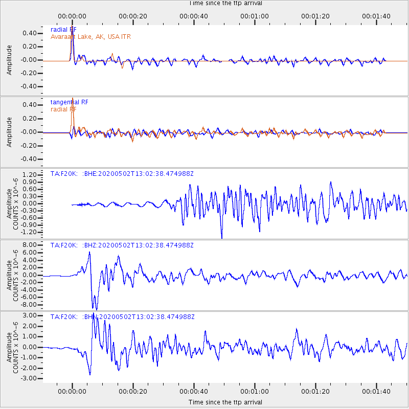
Signal To Noise
| Channel | StoN | STA | LTA |
| TA:F20K: :BHZ:20200502T13:02:38.474988Z | 21.217081 | 1.2530302E-6 | 5.9057612E-8 |
| TA:F20K: :BHN:20200502T13:02:38.474988Z | 11.567766 | 4.178891E-7 | 3.6125307E-8 |
| TA:F20K: :BHE:20200502T13:02:38.474988Z | 2.5498083 | 1.2769506E-7 | 5.008026E-8 |
| Arrivals |
| Ps | 4.4 SECOND |
| PpPs | 16 SECOND |
| PsPs/PpSs | 20 SECOND |


