You are here: Home > Network List > TA - USArray Transportable Network (new EarthScope stations) Stations List
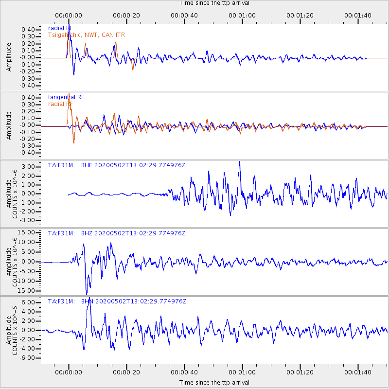
> Station F31M Tsiigehtchic, NWT, CAN > Earthquake Result Viewer
F31M Tsiigehtchic, NWT, CAN - Earthquake Result Viewer
| Earthquake location: |
Crete, Greece |
| Earthquake latitude/longitude: |
34.2/25.7 |
| Earthquake time(UTC): |
2020/05/02 (123) 12:51:06 GMT |
| Earthquake Depth: |
17 km |
| Earthquake Magnitude: |
6.6 mww |
| Earthquake Catalog/Contributor: |
NEIC PDE/us |
|
| Network: |
TA USArray Transportable Network (new EarthScope stations) |
| Station: |
F31M Tsiigehtchic, NWT, CAN |
| Lat/Lon: |
67.44 N/133.74 W |
| Elevation: |
56 m |
|
| Distance: |
77.5 deg |
| Az: |
352.027 deg |
| Baz: |
17.335 deg |
| Ray Param: |
0.050288938 |
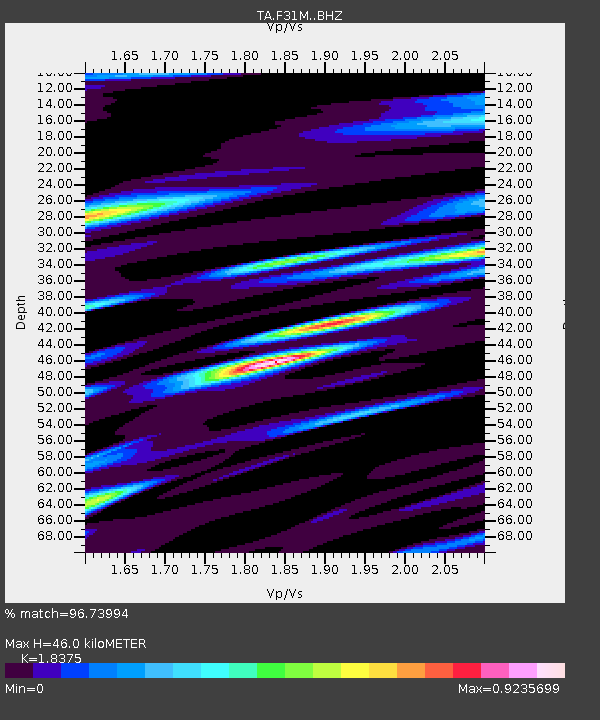
| Estimated Moho Depth: |
46.0 km |
| Estimated Crust Vp/Vs: |
1.84 |
| Assumed Crust Vp: |
6.171 km/s |
| Estimated Crust Vs: |
3.359 km/s |
| Estimated Crust Poisson's Ratio: |
0.29 |
|
| Radial Match: |
96.73994 % |
| Radial Bump: |
400 |
| Transverse Match: |
93.66986 % |
| Transverse Bump: |
400 |
| SOD ConfigId: |
21166931 |
| Insert Time: |
2020-05-16 13:14:26.242 +0000 |
| GWidth: |
2.5 |
| Max Bumps: |
400 |
| Tol: |
0.001 |
|
Signal To Noise
| Channel | StoN | STA | LTA |
| TA:F31M: :BHZ:20200502T13:02:29.774976Z | 28.030771 | 2.2249485E-6 | 7.937522E-8 |
| TA:F31M: :BHN:20200502T13:02:29.774976Z | 5.297201 | 7.2442685E-7 | 1.3675654E-7 |
| TA:F31M: :BHE:20200502T13:02:29.774976Z | 1.5711809 | 1.4661964E-7 | 9.331812E-8 |
| Arrivals |
| Ps | 6.4 SECOND |
| PpPs | 21 SECOND |
| PsPs/PpSs | 27 SECOND |


