You are here: Home > Network List > TA - USArray Transportable Network (new EarthScope stations) Stations List
> Station H18K Honhosa River, AK, USA > Earthquake Result Viewer
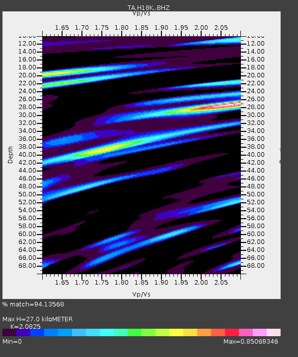
H18K Honhosa River, AK, USA - Earthquake Result Viewer
| Earthquake location: |
Crete, Greece |
| Earthquake latitude/longitude: |
34.2/25.7 |
| Earthquake time(UTC): |
2020/05/02 (123) 12:51:06 GMT |
| Earthquake Depth: |
17 km |
| Earthquake Magnitude: |
6.6 mww |
| Earthquake Catalog/Contributor: |
NEIC PDE/us |
|
| Network: |
TA USArray Transportable Network (new EarthScope stations) |
| Station: |
H18K Honhosa River, AK, USA |
| Lat/Lon: |
65.15 N/158.36 W |
| Elevation: |
494 m |
|
| Distance: |
80.9 deg |
| Az: |
1.743 deg |
| Baz: |
356.58 deg |
| Ray Param: |
0.047939524 |
| Estimated Moho Depth: |
27.0 km |
| Estimated Crust Vp/Vs: |
2.08 |
| Assumed Crust Vp: |
6.1 km/s |
| Estimated Crust Vs: |
2.929 km/s |
| Estimated Crust Poisson's Ratio: |
0.35 |
|
| Radial Match: |
94.13568 % |
| Radial Bump: |
400 |
| Transverse Match: |
85.56334 % |
| Transverse Bump: |
400 |
| SOD ConfigId: |
21166931 |
| Insert Time: |
2020-05-16 13:14:51.757 +0000 |
| GWidth: |
2.5 |
| Max Bumps: |
400 |
| Tol: |
0.001 |
|

Signal To Noise
| Channel | StoN | STA | LTA |
| TA:H18K: :BHZ:20200502T13:02:48.500013Z | 18.0217 | 1.3615125E-6 | 7.5548506E-8 |
| TA:H18K: :BHN:20200502T13:02:48.500013Z | 5.8397236 | 5.414216E-7 | 9.271357E-8 |
| TA:H18K: :BHE:20200502T13:02:48.500013Z | 1.2026219 | 8.284151E-8 | 6.8884084E-8 |
| Arrivals |
| Ps | 4.9 SECOND |
| PpPs | 13 SECOND |
| PsPs/PpSs | 18 SECOND |


