You are here: Home > Network List > TA - USArray Transportable Network (new EarthScope stations) Stations List
> Station H31M Peel River, Yukon, CAN > Earthquake Result Viewer
H31M Peel River, Yukon, CAN - Earthquake Result Viewer
| Earthquake location: |
Crete, Greece |
| Earthquake latitude/longitude: |
34.2/25.7 |
| Earthquake time(UTC): |
2020/05/02 (123) 12:51:06 GMT |
| Earthquake Depth: |
17 km |
| Earthquake Magnitude: |
6.6 mww |
| Earthquake Catalog/Contributor: |
NEIC PDE/us |
|
| Network: |
TA USArray Transportable Network (new EarthScope stations) |
| Station: |
H31M Peel River, Yukon, CAN |
| Lat/Lon: |
65.81 N/134.34 W |
| Elevation: |
642 m |
|
| Distance: |
79.1 deg |
| Az: |
351.769 deg |
| Baz: |
16.732 deg |
| Ray Param: |
0.049170993 |
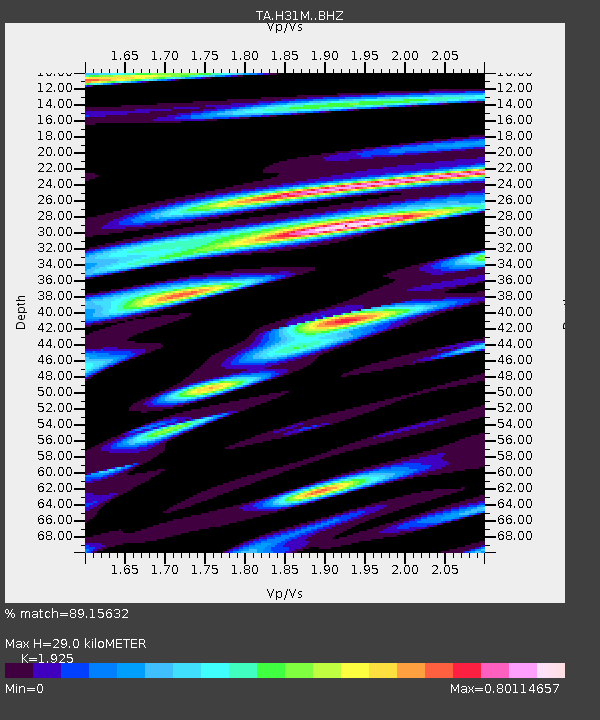
| Estimated Moho Depth: |
29.0 km |
| Estimated Crust Vp/Vs: |
1.92 |
| Assumed Crust Vp: |
6.419 km/s |
| Estimated Crust Vs: |
3.335 km/s |
| Estimated Crust Poisson's Ratio: |
0.32 |
|
| Radial Match: |
89.15632 % |
| Radial Bump: |
400 |
| Transverse Match: |
84.07423 % |
| Transverse Bump: |
400 |
| SOD ConfigId: |
21166931 |
| Insert Time: |
2020-05-16 13:14:58.346 +0000 |
| GWidth: |
2.5 |
| Max Bumps: |
400 |
| Tol: |
0.001 |
|

Signal To Noise
| Channel | StoN | STA | LTA |
| TA:H31M: :BHZ:20200502T13:02:38.825025Z | 15.612956 | 1.5524901E-6 | 9.9436015E-8 |
| TA:H31M: :BHN:20200502T13:02:38.825025Z | 5.1835737 | 5.6617364E-7 | 1.0922457E-7 |
| TA:H31M: :BHE:20200502T13:02:38.825025Z | 1.3191997 | 1.759914E-7 | 1.334077E-7 |
| Arrivals |
| Ps | 4.3 SECOND |
| PpPs | 13 SECOND |
| PsPs/PpSs | 17 SECOND |


