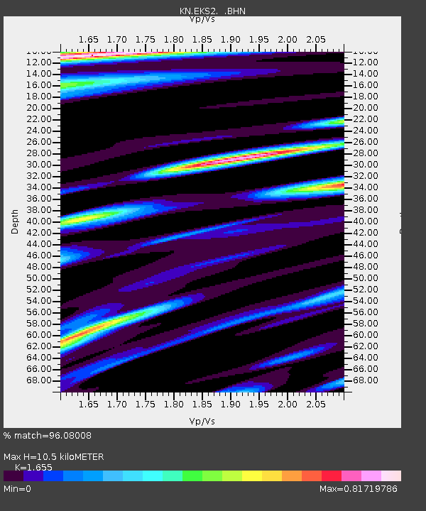
EKS2 KN.EKS2 - Earthquake Result Viewer
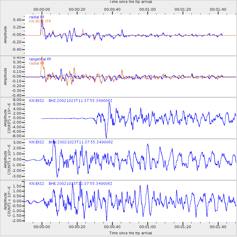
Earthquake location: Central Alaska
Earthquake latitude/longitude: 63.5/-147.9
Earthquake time(UTC): 2002/10/23 (296) 11:27:19 GMT
Earthquake Depth: 4.2 km
Earthquake Magnitude: 6.0 MB, 6.7 MS, 6.7 MW, 6.7 MW
Earthquake Catalog/Contributor: WHDF/NEIC
Network: KN Kyrgyz Seismic Telemetry Network
Station: EKS2 KN.EKS2
Lat/Lon: 42.66 N/73.78 E
Elevation: 1360 m
Distance: 69.1 deg
Az: 328.325 deg
Baz: 18.614 deg
Ray Param: 0.055874385
Estimated Moho Depth: 10.5 km
Estimated Crust Vp/Vs: 1.65
Assumed Crust Vp: 6.316 km/s
Estimated Crust Vs: 3.816 km/s
Estimated Crust Poisson's Ratio: 0.21
Radial Match: 96.08008 %
Radial Bump: 400
Transverse Match: 88.74822 %
Transverse Bump: 400
SOD ConfigId: 4714
Insert Time: 2010-03-08 19:44:21.246 +0000
GWidth: 2.5
Max Bumps: 400
Tol: 0.001

Signal To Noise

ChannelStoNSTALTA
KN:EKS2: :BHN:20021023T11:37:55.349006Z6.39679574.809143E-77.5180495E-8
KN:EKS2: :BHE:20021023T11:37:55.349006Z2.65926052.4037004E-79.038981E-8
KN:EKS2: :BHZ:20021023T11:37:55.349006Z16.531541.3195069E-67.981754E-8
Arrivals
Ps1.1 SECOND
PpPs4.2 SECOND
PsPs/PpSs5.4 SECOND