You are here: Home > Network List > TA - USArray Transportable Network (new EarthScope stations) Stations List
> Station R31K City Hall, Gustavus, AK, USA > Earthquake Result Viewer
R31K City Hall, Gustavus, AK, USA - Earthquake Result Viewer
| Earthquake location: |
Crete, Greece |
| Earthquake latitude/longitude: |
34.2/25.7 |
| Earthquake time(UTC): |
2020/05/02 (123) 12:51:06 GMT |
| Earthquake Depth: |
17 km |
| Earthquake Magnitude: |
6.6 mww |
| Earthquake Catalog/Contributor: |
NEIC PDE/us |
|
| Network: |
TA USArray Transportable Network (new EarthScope stations) |
| Station: |
R31K City Hall, Gustavus, AK, USA |
| Lat/Lon: |
58.41 N/135.74 W |
| Elevation: |
15 m |
|
| Distance: |
86.4 deg |
| Az: |
350.343 deg |
| Baz: |
15.316 deg |
| Ray Param: |
0.044044536 |
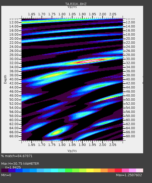
| Estimated Moho Depth: |
30.75 km |
| Estimated Crust Vp/Vs: |
1.94 |
| Assumed Crust Vp: |
6.566 km/s |
| Estimated Crust Vs: |
3.38 km/s |
| Estimated Crust Poisson's Ratio: |
0.32 |
|
| Radial Match: |
84.67871 % |
| Radial Bump: |
400 |
| Transverse Match: |
75.47592 % |
| Transverse Bump: |
400 |
| SOD ConfigId: |
21166931 |
| Insert Time: |
2020-05-16 13:16:14.988 +0000 |
| GWidth: |
2.5 |
| Max Bumps: |
400 |
| Tol: |
0.001 |
|

Signal To Noise
| Channel | StoN | STA | LTA |
| TA:R31K: :BHZ:20200502T13:03:16.649976Z | 4.447448 | 1.1659401E-6 | 2.6215938E-7 |
| TA:R31K: :BHN:20200502T13:03:16.649976Z | 1.6006238 | 5.899727E-7 | 3.685892E-7 |
| TA:R31K: :BHE:20200502T13:03:16.649976Z | 1.3606385 | 6.0209004E-7 | 4.4250552E-7 |
| Arrivals |
| Ps | 4.5 SECOND |
| PpPs | 13 SECOND |
| PsPs/PpSs | 18 SECOND |


