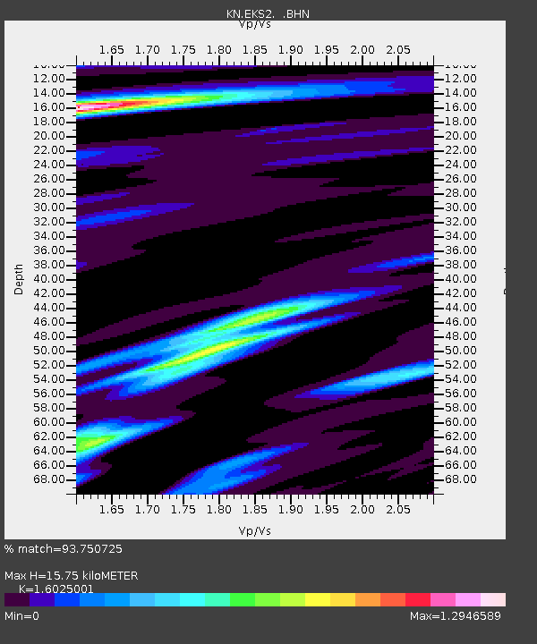
EKS2 KN.EKS2 - Earthquake Result Viewer
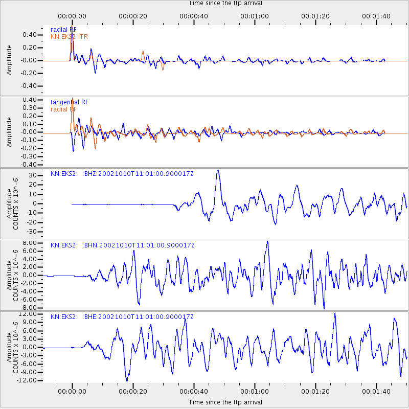
Earthquake location: Irian Jaya Region, Indonesia
Earthquake latitude/longitude: -1.8/134.3
Earthquake time(UTC): 2002/10/10 (283) 10:50:20 GMT
Earthquake Depth: 10 km
Earthquake Magnitude: 6.5 MB, 7.7 MS, 7.6 MW, 7.4 MW
Earthquake Catalog/Contributor: WHDF/NEIC
Network: KN Kyrgyz Seismic Telemetry Network
Station: EKS2 KN.EKS2
Lat/Lon: 42.66 N/73.78 E
Elevation: 1360 m
Distance: 70.0 deg
Az: 316.89 deg
Baz: 112.172 deg
Ray Param: 0.055283714
Estimated Moho Depth: 15.75 km
Estimated Crust Vp/Vs: 1.60
Assumed Crust Vp: 6.316 km/s
Estimated Crust Vs: 3.941 km/s
Estimated Crust Poisson's Ratio: 0.18
Radial Match: 93.750725 %
Radial Bump: 400
Transverse Match: 89.187515 %
Transverse Bump: 400
SOD ConfigId: 4714
Insert Time: 2010-03-08 19:44:40.386 +0000
GWidth: 2.5
Max Bumps: 400
Tol: 0.001

Signal To Noise

ChannelStoNSTALTA
KN:EKS2: :BHN:20021010T11:01:00.900017Z1.59301228.2249215E-85.163125E-8
KN:EKS2: :BHE:20021010T11:01:00.900017Z12.1350755.9262317E-74.883556E-8
KN:EKS2: :BHZ:20021010T11:01:00.900017Z25.3992841.7674793E-66.9587756E-8
Arrivals
Ps1.6 SECOND
PpPs6.2 SECOND
PsPs/PpSs7.8 SECOND