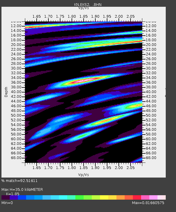
EKS2 KN.EKS2 - Earthquake Result Viewer
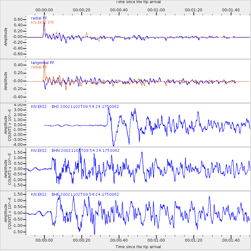
Earthquake location: Northern Sumatra, Indonesia
Earthquake latitude/longitude: 3.0/96.4
Earthquake time(UTC): 2002/11/02 (306) 09:46:46 GMT
Earthquake Depth: 27 km
Earthquake Magnitude: 5.9 MB, 6.4 MS, 6.4 MW, 6.1 MW
Earthquake Catalog/Contributor: WHDF/NEIC
Network: KN Kyrgyz Seismic Telemetry Network
Station: EKS2 KN.EKS2
Lat/Lon: 42.66 N/73.78 E
Elevation: 1360 m
Distance: 44.4 deg
Az: 336.078 deg
Baz: 146.701 deg
Ray Param: 0.0718991
Estimated Moho Depth: 35.0 km
Estimated Crust Vp/Vs: 1.85
Assumed Crust Vp: 6.316 km/s
Estimated Crust Vs: 3.414 km/s
Estimated Crust Poisson's Ratio: 0.29
Radial Match: 92.51611 %
Radial Bump: 400
Transverse Match: 81.889084 %
Transverse Bump: 400
SOD ConfigId: 4714
Insert Time: 2010-03-08 19:44:43.444 +0000
GWidth: 2.5
Max Bumps: 400
Tol: 0.001

Signal To Noise

ChannelStoNSTALTA
KN:EKS2: :BHN:20021102T09:54:24.175006Z5.5100053.7332498E-76.7754016E-8
KN:EKS2: :BHE:20021102T09:54:24.175006Z5.13323263.034088E-75.9106767E-8
KN:EKS2: :BHZ:20021102T09:54:24.175006Z14.1797671.1875255E-68.374789E-8
Arrivals
Ps5.0 SECOND
PpPs15 SECOND
PsPs/PpSs20 SECOND