You are here: Home > Network List > US - United States National Seismic Network Stations List
> Station GLMI Grayling, Michigan, USA > Earthquake Result Viewer
GLMI Grayling, Michigan, USA - Earthquake Result Viewer

| Earthquake location: |
Crete, Greece |
| Earthquake latitude/longitude: |
34.2/25.7 |
| Earthquake time(UTC): |
2020/05/02 (123) 12:51:06 GMT |
| Earthquake Depth: |
17 km |
| Earthquake Magnitude: |
6.6 mww |
| Earthquake Catalog/Contributor: |
NEIC PDE/us |
|
| Network: |
US United States National Seismic Network |
| Station: |
GLMI Grayling, Michigan, USA |
| Lat/Lon: |
44.82 N/84.62 W |
| Elevation: |
387 m |
|
| Distance: |
79.2 deg |
| Az: |
317.2 deg |
| Baz: |
52.307 deg |
| Ray Param: |
0.049150098 |
| Estimated Moho Depth: |
24.75 km |
| Estimated Crust Vp/Vs: |
1.60 |
| Assumed Crust Vp: |
6.483 km/s |
| Estimated Crust Vs: |
4.052 km/s |
| Estimated Crust Poisson's Ratio: |
0.18 |
|
| Radial Match: |
87.56563 % |
| Radial Bump: |
400 |
| Transverse Match: |
81.10633 % |
| Transverse Bump: |
400 |
| SOD ConfigId: |
21166931 |
| Insert Time: |
2020-05-16 13:18:14.402 +0000 |
| GWidth: |
2.5 |
| Max Bumps: |
400 |
| Tol: |
0.001 |
|
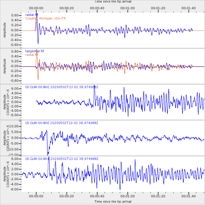
Signal To Noise
| Channel | StoN | STA | LTA |
| US:GLMI:00:BHZ:20200502T13:02:38.974988Z | 8.128247 | 1.8054922E-6 | 2.2212565E-7 |
| US:GLMI:00:BH1:20200502T13:02:38.974988Z | 1.130334 | 6.0854256E-7 | 5.3837414E-7 |
| US:GLMI:00:BH2:20200502T13:02:38.974988Z | 1.7424284 | 8.262248E-7 | 4.7418E-7 |
| Arrivals |
| Ps | 2.4 SECOND |
| PpPs | 9.6 SECOND |
| PsPs/PpSs | 12 SECOND |


