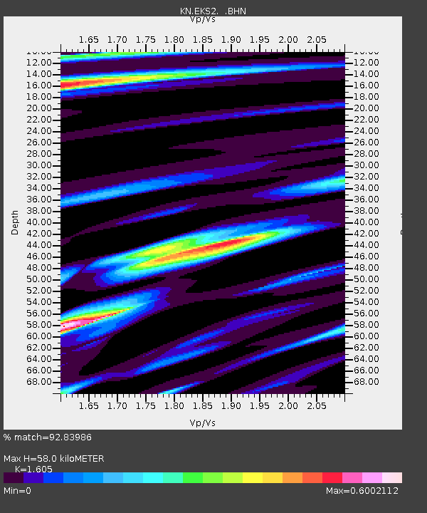
EKS2 KN.EKS2 - Earthquake Result Viewer
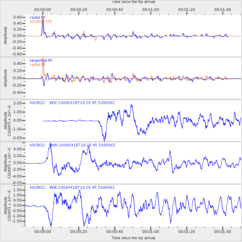
Earthquake location: Kuril Islands
Earthquake latitude/longitude: 46.0/151.4
Earthquake time(UTC): 2009/04/18 (108) 19:17:58 GMT
Earthquake Depth: 35 km
Earthquake Magnitude: 6.3 MB, 6.3 MS, 6.6 MW, 6.4 MW
Earthquake Catalog/Contributor: WHDF/NEIC
Network: KN Kyrgyz Seismic Telemetry Network
Station: EKS2 KN.EKS2
Lat/Lon: 42.66 N/73.78 E
Elevation: 1360 m
Distance: 53.5 deg
Az: 296.38 deg
Baz: 57.819 deg
Ray Param: 0.06595985
Estimated Moho Depth: 58.0 km
Estimated Crust Vp/Vs: 1.61
Assumed Crust Vp: 6.316 km/s
Estimated Crust Vs: 3.935 km/s
Estimated Crust Poisson's Ratio: 0.18
Radial Match: 92.83986 %
Radial Bump: 400
Transverse Match: 82.884415 %
Transverse Bump: 400
SOD ConfigId: 2760
Insert Time: 2010-03-08 19:46:17.676 +0000
GWidth: 2.5
Max Bumps: 400
Tol: 0.001

Signal To Noise

ChannelStoNSTALTA
KN:EKS2: :BHN:20090418T19:26:45.599006Z54.4449042.737745E-65.0284687E-8
KN:EKS2: :BHE:20090418T19:26:45.599006Z22.6123758.6167256E-73.810624E-8
KN:EKS2: :BHZ:20090418T19:26:45.599006Z29.0093781.0976596E-63.7838095E-8
Arrivals
Ps5.9 SECOND
PpPs23 SECOND
PsPs/PpSs28 SECOND