You are here: Home > Network List > LM - Michigan State University Seismic Network Stations List
> Station L48A N Adams, MI, USA > Earthquake Result Viewer
L48A N Adams, MI, USA - Earthquake Result Viewer
| Earthquake location: |
Southern Peru |
| Earthquake latitude/longitude: |
-15.3/-70.4 |
| Earthquake time(UTC): |
2020/05/03 (124) 00:44:26 GMT |
| Earthquake Depth: |
186 km |
| Earthquake Magnitude: |
5.7 Mww |
| Earthquake Catalog/Contributor: |
NEIC PDE/us |
|
| Network: |
LM Michigan State University Seismic Network |
| Station: |
L48A N Adams, MI, USA |
| Lat/Lon: |
41.94 N/84.43 W |
| Elevation: |
369 m |
|
| Distance: |
58.4 deg |
| Az: |
347.757 deg |
| Baz: |
164.081 deg |
| Ray Param: |
0.062251087 |
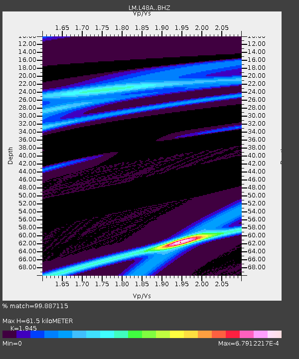
| Estimated Moho Depth: |
61.5 km |
| Estimated Crust Vp/Vs: |
1.95 |
| Assumed Crust Vp: |
6.498 km/s |
| Estimated Crust Vs: |
3.341 km/s |
| Estimated Crust Poisson's Ratio: |
0.32 |
|
| Radial Match: |
99.887115 % |
| Radial Bump: |
14 |
| Transverse Match: |
99.95162 % |
| Transverse Bump: |
4 |
| SOD ConfigId: |
21166931 |
| Insert Time: |
2020-05-17 00:53:58.942 +0000 |
| GWidth: |
2.5 |
| Max Bumps: |
400 |
| Tol: |
0.001 |
|

Signal To Noise
| Channel | StoN | STA | LTA |
| LM:L48A: :BHZ:20200503T00:53:31.523999Z | 1.0360509 | 1.3596809E-5 | 1.31236875E-5 |
| LM:L48A: :BHN:20200503T00:53:31.523999Z | 0.9417007 | 2.6275777E-7 | 2.790247E-7 |
| LM:L48A: :BHE:20200503T00:53:31.523999Z | 0.99027216 | 3.2321177E-6 | 3.263868E-6 |
| Arrivals |
| Ps | 9.4 SECOND |
| PpPs | 27 SECOND |
| PsPs/PpSs | 36 SECOND |


