You are here: Home > Network List > KN - Kyrgyz Seismic Telemetry Network Stations List
> Station EKS2 KN.EKS2 > Earthquake Result Viewer
EKS2 KN.EKS2 - Earthquake Result Viewer

| Earthquake location: |
Banda Sea |
| Earthquake latitude/longitude: |
-7.5/127.9 |
| Earthquake time(UTC): |
2008/06/06 (158) 13:42:48 GMT |
| Earthquake Depth: |
122 km |
| Earthquake Magnitude: |
5.7 MB, 6.0 MW, 6.0 MW |
| Earthquake Catalog/Contributor: |
WHDF/NEIC |
|
| Network: |
KN Kyrgyz Seismic Telemetry Network |
| Station: |
EKS2 KN.EKS2 |
| Lat/Lon: |
42.66 N/73.78 E |
| Elevation: |
1360 m |
|
| Distance: |
70.0 deg |
| Az: |
320.524 deg |
| Baz: |
121.283 deg |
| Ray Param: |
0.05492715 |
| Estimated Moho Depth: |
15.75 km |
| Estimated Crust Vp/Vs: |
1.60 |
| Assumed Crust Vp: |
6.316 km/s |
| Estimated Crust Vs: |
3.947 km/s |
| Estimated Crust Poisson's Ratio: |
0.18 |
|
| Radial Match: |
92.060974 % |
| Radial Bump: |
400 |
| Transverse Match: |
89.34579 % |
| Transverse Bump: |
400 |
| SOD ConfigId: |
2504 |
| Insert Time: |
2010-03-08 19:46:57.312 +0000 |
| GWidth: |
2.5 |
| Max Bumps: |
400 |
| Tol: |
0.001 |
|
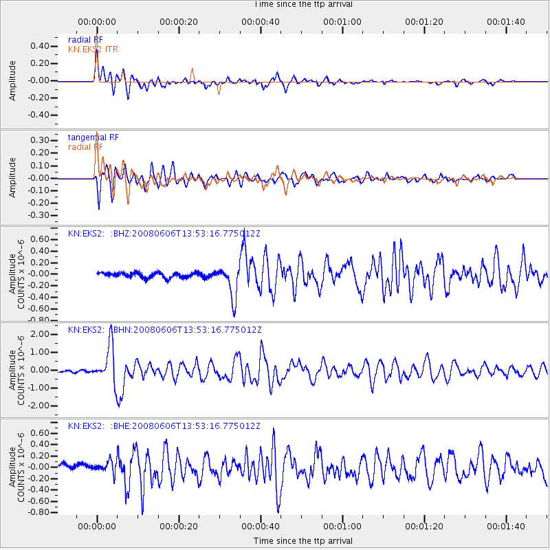
Signal To Noise
| Channel | StoN | STA | LTA |
| KN:EKS2: :BHN:20080606T13:53:16.775012Z | 21.374538 | 1.1061081E-6 | 5.174887E-8 |
| KN:EKS2: :BHE:20080606T13:53:16.775012Z | 1.4739147 | 1.06913824E-7 | 7.253731E-8 |
| KN:EKS2: :BHZ:20080606T13:53:16.775012Z | 6.2992783 | 2.8472178E-7 | 4.5199112E-8 |
| Arrivals |
| Ps | 1.6 SECOND |
| PpPs | 6.2 SECOND |
| PsPs/PpSs | 7.8 SECOND |


