You are here: Home > Network List > O2 - Oklahoma Consolidated Temporary Seismic Networks Stations List
> Station PW30 Pawnee, Oklahoma, USA > Earthquake Result Viewer
PW30 Pawnee, Oklahoma, USA - Earthquake Result Viewer
| Earthquake location: |
Southern Peru |
| Earthquake latitude/longitude: |
-15.3/-70.4 |
| Earthquake time(UTC): |
2020/05/03 (124) 00:44:26 GMT |
| Earthquake Depth: |
186 km |
| Earthquake Magnitude: |
5.7 Mww |
| Earthquake Catalog/Contributor: |
NEIC PDE/us |
|
| Network: |
O2 Oklahoma Consolidated Temporary Seismic Networks |
| Station: |
PW30 Pawnee, Oklahoma, USA |
| Lat/Lon: |
36.42 N/96.82 W |
| Elevation: |
314 m |
|
| Distance: |
57.2 deg |
| Az: |
334.735 deg |
| Baz: |
149.299 deg |
| Ray Param: |
0.063051604 |
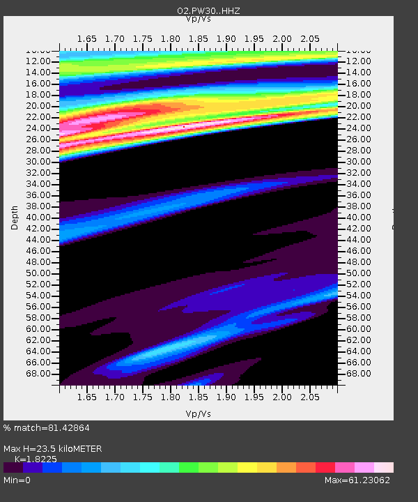
| Estimated Moho Depth: |
23.5 km |
| Estimated Crust Vp/Vs: |
1.82 |
| Assumed Crust Vp: |
6.483 km/s |
| Estimated Crust Vs: |
3.557 km/s |
| Estimated Crust Poisson's Ratio: |
0.28 |
|
| Radial Match: |
81.42864 % |
| Radial Bump: |
399 |
| Transverse Match: |
93.62595 % |
| Transverse Bump: |
310 |
| SOD ConfigId: |
21166931 |
| Insert Time: |
2020-05-17 00:58:32.703 +0000 |
| GWidth: |
2.5 |
| Max Bumps: |
400 |
| Tol: |
0.001 |
|

Signal To Noise
| Channel | StoN | STA | LTA |
| O2:PW30: :HHZ:20200503T00:53:22.890027Z | 10.051743 | 1.2569674E-6 | 1.250497E-7 |
| O2:PW30: :HHN:20200503T00:53:22.890027Z | 1.209538 | 3.2610717E-6 | 2.6961302E-6 |
| O2:PW30: :HHE:20200503T00:53:22.890027Z | 1.8324088 | 1.2565413E-5 | 6.85732E-6 |
| Arrivals |
| Ps | 3.1 SECOND |
| PpPs | 9.7 SECOND |
| PsPs/PpSs | 13 SECOND |


