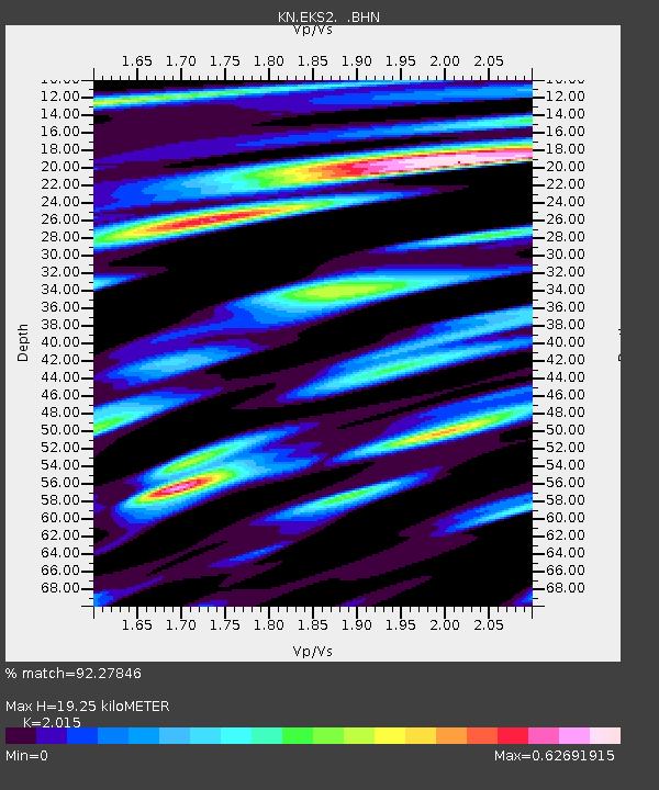
EKS2 KN.EKS2 - Earthquake Result Viewer
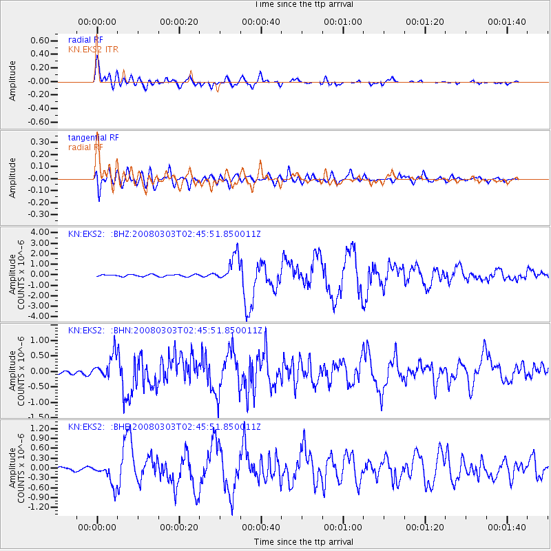
Earthquake location: Southern Sumatra, Indonesia
Earthquake latitude/longitude: -2.2/99.8
Earthquake time(UTC): 2008/03/03 (063) 02:37:27 GMT
Earthquake Depth: 25 km
Earthquake Magnitude: 5.8 MB, 6.1 MS, 6.1 MW, 6.1 MW
Earthquake Catalog/Contributor: WHDF/NEIC
Network: KN Kyrgyz Seismic Telemetry Network
Station: EKS2 KN.EKS2
Lat/Lon: 42.66 N/73.78 E
Elevation: 1360 m
Distance: 50.5 deg
Az: 335.163 deg
Baz: 145.317 deg
Ray Param: 0.068007536
Estimated Moho Depth: 19.25 km
Estimated Crust Vp/Vs: 2.02
Assumed Crust Vp: 6.316 km/s
Estimated Crust Vs: 3.134 km/s
Estimated Crust Poisson's Ratio: 0.34
Radial Match: 92.27846 %
Radial Bump: 400
Transverse Match: 85.327156 %
Transverse Bump: 400
SOD ConfigId: 2564
Insert Time: 2010-03-08 19:47:54.834 +0000
GWidth: 2.5
Max Bumps: 400
Tol: 0.001

Signal To Noise

ChannelStoNSTALTA
KN:EKS2: :BHN:20080303T02:45:51.850011Z3.82039743.820347E-79.999868E-8
KN:EKS2: :BHE:20080303T02:45:51.850011Z5.13189463.500751E-76.821557E-8
KN:EKS2: :BHZ:20080303T02:45:51.850011Z14.2509821.304975E-69.1570875E-8
Arrivals
Ps3.2 SECOND
PpPs8.8 SECOND
PsPs/PpSs12 SECOND