You are here: Home > Network List > TX - Texas Seismological Network Stations List
> Station WTFS Witchita Falls > Earthquake Result Viewer
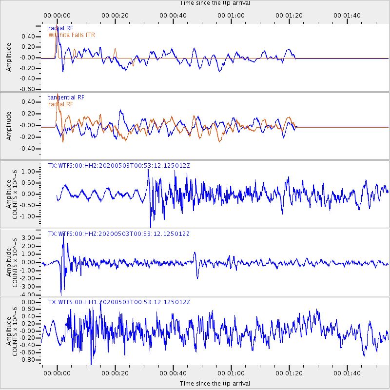
WTFS Witchita Falls - Earthquake Result Viewer
*The percent match for this event was below the threshold and hence no stack was calculated.
| Earthquake location: |
Southern Peru |
| Earthquake latitude/longitude: |
-15.3/-70.4 |
| Earthquake time(UTC): |
2020/05/03 (124) 00:44:26 GMT |
| Earthquake Depth: |
186 km |
| Earthquake Magnitude: |
5.7 Mww |
| Earthquake Catalog/Contributor: |
NEIC PDE/us |
|
| Network: |
TX Texas Seismological Network |
| Station: |
WTFS Witchita Falls |
| Lat/Lon: |
33.77 N/98.46 W |
| Elevation: |
277 m |
|
| Distance: |
55.7 deg |
| Az: |
331.681 deg |
| Baz: |
146.67 deg |
| Ray Param: |
$rayparam |
*The percent match for this event was below the threshold and hence was not used in the summary stack. |
|
| Radial Match: |
44.860626 % |
| Radial Bump: |
400 |
| Transverse Match: |
44.93102 % |
| Transverse Bump: |
400 |
| SOD ConfigId: |
21166931 |
| Insert Time: |
2020-05-17 01:03:43.948 +0000 |
| GWidth: |
2.5 |
| Max Bumps: |
400 |
| Tol: |
0.001 |
|
Signal To Noise
| Channel | StoN | STA | LTA |
| TX:WTFS:00:HHZ:20200503T00:53:12.125012Z | 12.834147 | 1.448064E-6 | 1.1282899E-7 |
| TX:WTFS:00:HH1:20200503T00:53:12.125012Z | 1.4798858 | 2.5684184E-7 | 1.7355518E-7 |
| TX:WTFS:00:HH2:20200503T00:53:12.125012Z | 3.6392784 | 5.8543225E-7 | 1.6086491E-7 |
| Arrivals |
| Ps | |
| PpPs | |
| PsPs/PpSs | |


