You are here: Home > Network List > US - United States National Seismic Network Stations List
> Station CBKS Cedar Bluff, Kansas, USA > Earthquake Result Viewer
CBKS Cedar Bluff, Kansas, USA - Earthquake Result Viewer
*The percent match for this event was below the threshold and hence no stack was calculated.
| Earthquake location: |
Southern Peru |
| Earthquake latitude/longitude: |
-15.3/-70.4 |
| Earthquake time(UTC): |
2020/05/03 (124) 00:44:26 GMT |
| Earthquake Depth: |
186 km |
| Earthquake Magnitude: |
5.7 Mww |
| Earthquake Catalog/Contributor: |
NEIC PDE/us |
|
| Network: |
US United States National Seismic Network |
| Station: |
CBKS Cedar Bluff, Kansas, USA |
| Lat/Lon: |
38.81 N/99.74 W |
| Elevation: |
677 m |
|
| Distance: |
60.4 deg |
| Az: |
333.909 deg |
| Baz: |
147.099 deg |
| Ray Param: |
$rayparam |
*The percent match for this event was below the threshold and hence was not used in the summary stack. |
|
| Radial Match: |
47.720383 % |
| Radial Bump: |
400 |
| Transverse Match: |
37.485558 % |
| Transverse Bump: |
400 |
| SOD ConfigId: |
21166931 |
| Insert Time: |
2020-05-17 01:04:32.181 +0000 |
| GWidth: |
2.5 |
| Max Bumps: |
400 |
| Tol: |
0.001 |
|
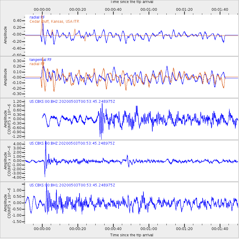
Signal To Noise
| Channel | StoN | STA | LTA |
| US:CBKS:00:BHZ:20200503T00:53:45.248975Z | 7.896386 | 1.3166444E-6 | 1.6674014E-7 |
| US:CBKS:00:BH1:20200503T00:53:45.248975Z | 2.2868726 | 5.0688465E-7 | 2.216497E-7 |
| US:CBKS:00:BH2:20200503T00:53:45.248975Z | 2.4909668 | 5.044059E-7 | 2.0249401E-7 |
| Arrivals |
| Ps | |
| PpPs | |
| PsPs/PpSs | |


