You are here: Home > Network List > US - United States National Seismic Network Stations List
> Station HAWA Hanford, Washington, USA > Earthquake Result Viewer
HAWA Hanford, Washington, USA - Earthquake Result Viewer
*The percent match for this event was below the threshold and hence no stack was calculated.
| Earthquake location: |
Southern Peru |
| Earthquake latitude/longitude: |
-15.3/-70.4 |
| Earthquake time(UTC): |
2020/05/03 (124) 00:44:26 GMT |
| Earthquake Depth: |
186 km |
| Earthquake Magnitude: |
5.7 Mww |
| Earthquake Catalog/Contributor: |
NEIC PDE/us |
|
| Network: |
US United States National Seismic Network |
| Station: |
HAWA Hanford, Washington, USA |
| Lat/Lon: |
46.39 N/119.53 W |
| Elevation: |
364 m |
|
| Distance: |
75.7 deg |
| Az: |
327.31 deg |
| Baz: |
131.155 deg |
| Ray Param: |
$rayparam |
*The percent match for this event was below the threshold and hence was not used in the summary stack. |
|
| Radial Match: |
46.230232 % |
| Radial Bump: |
400 |
| Transverse Match: |
32.451416 % |
| Transverse Bump: |
400 |
| SOD ConfigId: |
21166931 |
| Insert Time: |
2020-05-17 01:04:43.217 +0000 |
| GWidth: |
2.5 |
| Max Bumps: |
400 |
| Tol: |
0.001 |
|
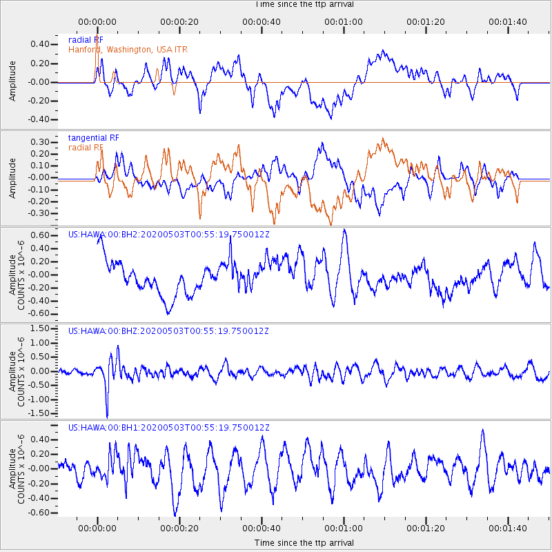
Signal To Noise
| Channel | StoN | STA | LTA |
| US:HAWA:00:BHZ:20200503T00:55:19.750012Z | 4.249077 | 5.29979E-7 | 1.2472803E-7 |
| US:HAWA:00:BH1:20200503T00:55:19.750012Z | 1.539212 | 1.6305313E-7 | 1.0593287E-7 |
| US:HAWA:00:BH2:20200503T00:55:19.750012Z | 1.0054203 | 2.6695568E-7 | 2.655165E-7 |
| Arrivals |
| Ps | |
| PpPs | |
| PsPs/PpSs | |


