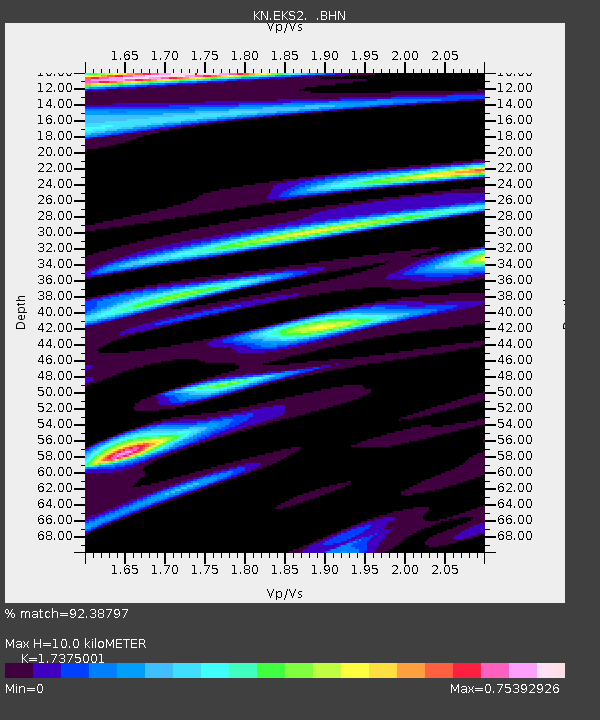
EKS2 KN.EKS2 - Earthquake Result Viewer
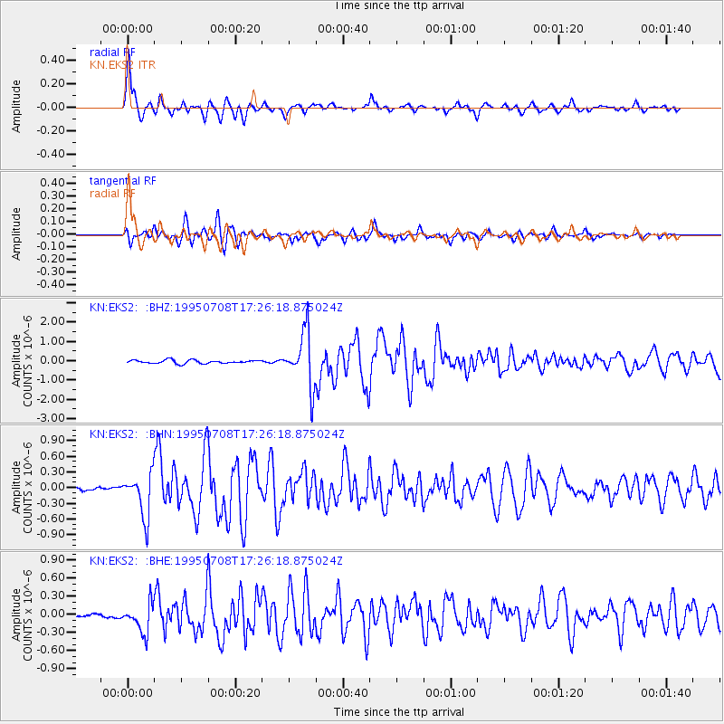
Earthquake location: Unimak Island Region, Alaska
Earthquake latitude/longitude: 53.6/-163.5
Earthquake time(UTC): 1995/07/08 (189) 17:15:28 GMT
Earthquake Depth: 33 km
Earthquake Magnitude: 5.8 MB, 5.7 MS, 5.5 UNKNOWN, 6.0 MW
Earthquake Catalog/Contributor: WHDF/NEIC
Network: KN Kyrgyz Seismic Telemetry Network
Station: EKS2 KN.EKS2
Lat/Lon: 42.66 N/73.78 E
Elevation: 1360 m
Distance: 72.2 deg
Az: 319.304 deg
Baz: 31.754 deg
Ray Param: 0.053757858
Estimated Moho Depth: 10.0 km
Estimated Crust Vp/Vs: 1.74
Assumed Crust Vp: 6.316 km/s
Estimated Crust Vs: 3.635 km/s
Estimated Crust Poisson's Ratio: 0.25
Radial Match: 92.38797 %
Radial Bump: 400
Transverse Match: 88.941956 %
Transverse Bump: 400
SOD ConfigId: 6273
Insert Time: 2010-03-08 19:48:24.156 +0000
GWidth: 2.5
Max Bumps: 400
Tol: 0.001

Signal To Noise

ChannelStoNSTALTA
KN:EKS2: :BHN:19950708T17:26:18.875024Z9.1240594.1626464E-74.562275E-8
KN:EKS2: :BHE:19950708T17:26:18.875024Z7.67334462.4248425E-73.1600855E-8
KN:EKS2: :BHZ:19950708T17:26:18.875024Z16.4250931.421827E-68.656433E-8
Arrivals
Ps1.2 SECOND
PpPs4.2 SECOND
PsPs/PpSs5.4 SECOND