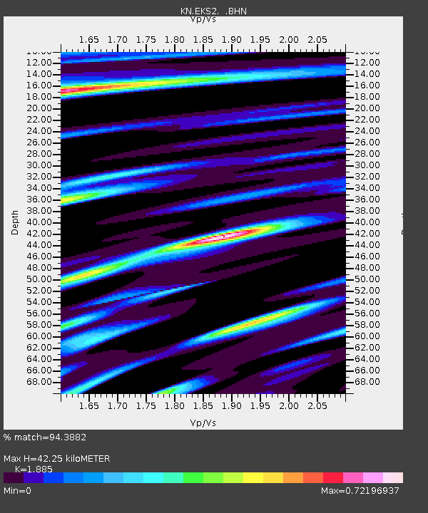
EKS2 KN.EKS2 - Earthquake Result Viewer
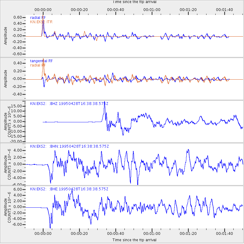
Earthquake location: Kuril Islands
Earthquake latitude/longitude: 44.1/148.1
Earthquake time(UTC): 1995/04/28 (118) 16:30:00 GMT
Earthquake Depth: 29 km
Earthquake Magnitude: 6.6 MB, 6.9 MS, 7.0 UNKNOWN, 6.8 MW
Earthquake Catalog/Contributor: WHDF/NEIC
Network: KN Kyrgyz Seismic Telemetry Network
Station: EKS2 KN.EKS2
Lat/Lon: 42.66 N/73.78 E
Elevation: 1360 m
Distance: 52.3 deg
Az: 296.129 deg
Baz: 61.345 deg
Ray Param: 0.06682018
Estimated Moho Depth: 42.25 km
Estimated Crust Vp/Vs: 1.88
Assumed Crust Vp: 6.316 km/s
Estimated Crust Vs: 3.35 km/s
Estimated Crust Poisson's Ratio: 0.30
Radial Match: 94.3882 %
Radial Bump: 400
Transverse Match: 84.59128 %
Transverse Bump: 400
SOD ConfigId: 6273
Insert Time: 2010-03-08 19:48:29.196 +0000
GWidth: 2.5
Max Bumps: 400
Tol: 0.001

Signal To Noise

ChannelStoNSTALTA
KN:EKS2: :BHN:19950428T16:38:38.575Z40.841431.8630336E-64.5616265E-8
KN:EKS2: :BHE:19950428T16:38:38.575Z62.192112.5617906E-64.119157E-8
KN:EKS2: :BHZ:19950428T16:38:38.575Z110.8947456.708863E-66.049758E-8
Arrivals
Ps6.2 SECOND
PpPs18 SECOND
PsPs/PpSs25 SECOND