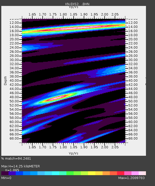
EKS2 KN.EKS2 - Earthquake Result Viewer
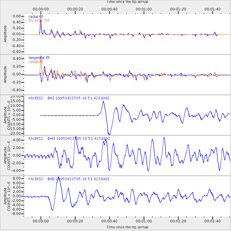
Earthquake location: Samar, Philippines
Earthquake latitude/longitude: 12.4/125.4
Earthquake time(UTC): 1995/04/23 (113) 05:08:03 GMT
Earthquake Depth: 33 km
Earthquake Magnitude: 6.0 MB, 6.6 MS, 6.7 UNKNOWN, 6.7 MW
Earthquake Catalog/Contributor: WHDF/NEIC
Network: KN Kyrgyz Seismic Telemetry Network
Station: EKS2 KN.EKS2
Lat/Lon: 42.66 N/73.78 E
Elevation: 1360 m
Distance: 53.7 deg
Az: 314.202 deg
Baz: 108.274 deg
Ray Param: 0.06584203
Estimated Moho Depth: 14.25 km
Estimated Crust Vp/Vs: 1.87
Assumed Crust Vp: 6.316 km/s
Estimated Crust Vs: 3.386 km/s
Estimated Crust Poisson's Ratio: 0.30
Radial Match: 94.2481 %
Radial Bump: 262
Transverse Match: 88.2489 %
Transverse Bump: 400
SOD ConfigId: 6273
Insert Time: 2010-03-08 19:48:48.198 +0000
GWidth: 2.5
Max Bumps: 400
Tol: 0.001

Signal To Noise

ChannelStoNSTALTA
KN:EKS2: :BHN:19950423T05:16:51.423999Z0.967240152.7823978E-72.876636E-7
KN:EKS2: :BHE:19950423T05:16:51.423999Z1.76546722.654814E-71.5037459E-7
KN:EKS2: :BHZ:19950423T05:16:51.423999Z4.2860718.9139184E-72.0797413E-7
Arrivals
Ps2.1 SECOND
PpPs6.2 SECOND
PsPs/PpSs8.2 SECOND